FAA Information Effective: Apr 17, 2025
All information is provided from the FAA unless otherwise noted.
(KBLF) Mercer County Airport
No ratings | 2 reviews
Bluefield, WV
(304) 327-5308
Overview
Attendance:
Attended
Year-round, 7 Days a Week,0600-2100
FAA
Runways:
05/23
Runway length: 4,743 ft (1,446 m)
Elevation:
2,857 ft (Surveyed)
Tower:
No
Airspace:
CLASS E SVC 0525-2125; OTHER TIMES CLASS G
FAA
Fees:
Landing, Overnight, Other
Click FBO link(s) below for details:
Click FBO link(s) below for details:
FBO Fee Details:
Mercer County Airport AuthorityTimezone:
EDT (UTC-04:00)
Sunrise-Sunset:
6:17 am - 8:27 pm
Evening-Morning Civil Twilight:
8:56 pm
(Today)
(Today)
-
5:47 am
(Tomorrow)
(Tomorrow)
Minimum Fuel Prices:
$7.10
100LL (full)
$7.00
100LL (self)
$5.40
Jet-A (full)
$5.30
Jet-A (self)
$5.48
Jet-A-Premix/Prist (full)
$5.38
Jet-A-Premix/Prist (self)
Runway
Satellite
Sectional
FBOs
Submit New FBO
Mercer County Airport Authority
1 rating | 1 review
Services Offered:
$7.10 | 100LL | full
$7.00 | 100LL | self
$5.40 | Jet-A | full
$5.30 | Jet-A | self
$5.48 | Jet-A-Premix/Prist | full
$5.38 | Jet-A-Premix/Prist | self
Location:
On field: S
Phone:
(304) 327-5308
Freq. Monitored:
UNICOM: 122.9
Fees:
Landing, Overnight, Other
Flight Training
Submit New Flight School
Other businesses
Submit New Business
AOPA Travel Discounts 
FlightBridge is the ultimate all-in-one travel booking platform built for the general aviation community. AOPA Members receive free access to FlightBridge with AOPA discounted rates automatically applied. Members save an average of 30% on hotel bookings! Learn more about FlightBridge HERE.
Local Food/Lodging/Activities
Local Attractions
Local Activities
Restaurants
Hotels and Lodging
Travel Discounts
Flying Clubs
Submit New Flying Club
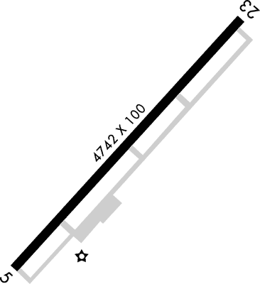
Runway 05/23
Dimensions:
4,743 × 100 ft
(1,446 × 30 m)
(1,446 × 30 m)
Weight Bearing Cap:
Single wheel: 30,000 lbs
Double wheel: 48,000 lbs
Double wheel: 48,000 lbs
Surface:
asphalt, grooved, in good condition
Runway Edge Lights:
High
Comments:
n/a
| Designator: | 05 | 23 |
| Elevation: | 2,850.2 ft | 2,856.4 ft |
| Heading: | 049° magnetic 042° true | 229° magnetic 222° true |
| Gradient: | 0.13% up | 0.13% down |
| Traffic Pattern: | Left Pattern | Left Pattern |
| Markings: | non-precision, in Fair condition | precision, in Fair condition |
| Approach Lighting: |
|
|
| Displaced Threshold: | n/a | n/a |
| ILS/LOC: | n/a | ILS |
| Obstructions: | Trees, 330 ft Right ft of center, 35 ft high, 201 ft from end | Trees, 300 ft Right ft of center, 40 ft high, 201 ft from end |
| Comments: | 35 Ft Trees, Up to 199 Ft Dstc, 300 Ft Right. FAA | 40 Ft Trees, 0 Ft Dstc, 300 Ft R. FAA |
TFRs
Location: BLF
Please verify all content below using the FAA TFR Search Site or with a flight briefer.
TFR count: 0
NOTAMs
Location: BLF
Please verify all content below using the FAA NOTAM Search Site or with a flight briefer.
NOTAM count: 7
| Number: | Start Date: (UTC) | End Date: (UTC) | Condition: |
|---|---|---|---|
| 5/0524 | 05/14/2025 1300 | IAP MERCER COUNTY, BLUEFIELD, WV.
ILS OR LOC RWY 23, AMDT 15G...
PROCEDURE NA EXCEPT FOR ACFT EQUIPPED WITH … | |
| 05/006 | 05/10/2025 0252 | 06/24/2025 0252 | OBST TOWER LGT (ASR 1310696) 372412.95N0812606.40W (12.5NM WNW BLF) 3101FT (305FT AGL) U/S |
| 05/011 | 05/14/2025 0146 | OBST TOWER LGT (ASN 2019-AEA-4709-OE) 372518N0811825W (8.9NM NNW BLF) 3754FT (350FT AGL) U/S | |
| 02/037 | 02/26/2025 1200 | 04/02/2026 2000 | NAV ILS RWY 23 OM U/S |
| 05/002 | 05/05/2025 0423 | 05/20/2025 0323 | OBST TOWER LGT (ASR 1240422) 371707.40N0811008.90W (1.9NM ESE BLF) 2654.9FT (252.0FT AGL) U/S |
| 03/001 | 03/03/2025 1423 | NAV VOR/DME 225-245 BEYOND 40NM UNUSABLE | |
| 5/2295 | 04/04/2025 1254 | ODP MERCER COUNTY, BLUEFIELD, WV.
TAKEOFF MINIMUMS AND (OBSTACLE) DEPARTURE PROCEDURES AMDT 4...
TAKEOFF MIN… | |
Additional Remarks
Deer & Birds on & In vicinity of Arpt.
Source:
FAA
Federal Aviation Administration
For Cd If Una to CTC on FSS Freq, CTC Indianapolis ARTCC at 317-247-2411.
Source:
FAA
Federal Aviation Administration
Mowing in Progress Apr-Nov All Sfcs.
Source:
FAA
Federal Aviation Administration
Rwy 05 Has Steep Drop-Off 175 Ft Fm Thr L Side.
Source:
FAA
Federal Aviation Administration
Rwy 23 Has Steep Drop-Off 320 Ft Fm Thr 0B, 280 Ft L and R.
Source:
FAA
Federal Aviation Administration
Noise Abatement
Instrument Procedures
Data Cycle:
Operations & More Information
Lat/Long:
- 37.29595, -81.20752
- 37° 17′ 45.4″ N, 81° 12′ 27.1″ W
- 37° 17.757′ N, 81° 12.451′ W
ARTCC:
Indianapolis (ZID)
App/Depart Control Facility:
Unknown
Chart:
NACO: Cincinnati Sectional
FSS:
Elkins (EKN)
1-800-WX-BRIEF
1-800-WX-BRIEF
Wind Indicator:
Lighted
Mag Var:
07W (2010)
NOTAM Facility:
Seg Circle:
No
Beacon:
Present
Lighting:
Pilot Activated Lighting:
- low intensity: 3 clicks in 15 secs
- medium intensity: 5 clicks in 15 secs
- high intensity: 7 clicks in 15 secs
AM
Actvt REIL Rwy 05 & 23; PAPI Rwy 05 & 23; HIRL Rwy 05/23; Twy Lights - CTAF.
FAA
Pattern Altitude:
No data provided. Assume 1000 AGL.
Special Operations:
Communications Card
| Type: | Frequency / Phone: | Sector / Comments: | Call Sign: |
|---|---|---|---|
| ASOS | 132.725T (304) 327-5766 | ||
| CTAF | 122.9 |
Navaids
Services
Fuel:
100LL Low-Lead, Jet A
AM
Engine Repair:
Major
AM
Airframe Repair:
Major
AM
Bottled Oxygen:
None
Bulk Oxygen:
None
Customs:
None
Transportation:
Courtesy Transportation
AM
Activities:
None Reported
Camping On Field:
None Reported
Aircraft & Activity
Webcams
METARs
TAFs
Contact Addresses
Airport Manager
Jim Pilkins
Bluefield, WV 24701
(304) 327-5308 (Office)
Owner
Mercer County Airport Authority Inc
Bluefield, WV 24701
(304) 327-5308 (Office)
Remarks:
Manager Cell 304-921-3417.
FAA
Airport Reviews
Overall:
No ratings | 2 reviews
Runways and Taxiways:No ratings
Markings and Signage:No ratings
Ground Transportation:No ratings
Sort By:
- 8/18/13RICHARD T.I landed here to pick up 2 dogs for pilots n paws. Other than that, there is absolutely no reason to stop here. The place was deserted. Two guys showed up out of nowhere to chock the plane, then they disappeared just as quickly as they showed up. Luc…
- 4/25/13GREGORY P.We visited on January 5. I am disappointed in our overall experience. The fuel farm is located some distance from the terminal. That meant a tow of the airplane to get it topped. So we left our airplane with the rampers and asked if they would tie it…