FAA Information Effective: May 15, 2025
All information is provided from the FAA unless otherwise noted.
(KBIS) Bismarck Municipal Airport
No ratings | No reviews
Overview
Attendance:
Attended
Year-round, 7 Days a Week,All
FAA
Elevation:
1,661 ft (Surveyed)
Tower:
Apch/Dep Svc Prvdd By Minneapolis Artcc On Freqs 135.25/256.7 (Woodworth Rcag) When Apch Clsd.
FAA
National Guard Operations 0630-1500 Mon-Fri; Except Hol; Other Times Prior Permission Required V362-2160.
FAA
Primary Approach Control Hrs: 0600-2400
FAA
Primary Depart. Control Hrs: 0600-2400
FAA
Secondary Approach Control Hrs: 2400-0600
FAA
Secondary Depart. Control Hrs: 2400-0600
FAA
Tower Hrs: 0600-2400
FAA
Airspace:
CLASS D SVC 0600-2400; OTHER TIMES CLASS E
FAA
Fees:
Landing, Overnight, Ramp, Tie Down, Other
Click FBO link(s) below for details:
Executive Air Taxi Corporation
Click FBO link(s) below for details:
FBO Fee Details:
Bismarck Aero CenterExecutive Air Taxi Corporation
Timezone:
CDT (UTC-05:00)
Sunrise-Sunset:
6:08 am - 9:13 pm
Evening-Morning Civil Twilight:
9:49 pm
(Today)
(Today)
-
5:30 am
(Tomorrow)
(Tomorrow)
Minimum Fuel Prices:
$6.75
100LL (full)
$5.65
Jet-A (full)
$5.70
Jet-A-Premix/Prist (full)
Runway
Satellite
Sectional
FBOs
Submit New FBO
Bismarck Aero Center
No ratings | 1 review
Services Offered:
Maintenance
Plane Rental
Car Rental
Sales
Flight Training
$6.75 | 100LL | full
$5.65 | Jet-A | full
$5.70 | Jet-A-Premix/Prist | full
Location:
On field: NW
Phone:
(701) 223-4754
Freq. Monitored:
UNICOM: 122.95
Fees:
Landing, Ramp, Other
Executive Air Taxi Corporation
1 rating | 1 review
Services Offered:
Maintenance
Plane Rental
Car Rental
Sales
Flight Training
$6.75 | 100LL | full
$5.65 | Jet-A | full
$5.70 | Jet-A-Premix/Prist | full
Location:
On field: NW
Phone:
(701) 258-5024
Freq. Monitored:
UNICOM: 122.95
Fees:
Landing, Overnight, Ramp, Tie Down, Other
Flight Training
Submit New Flight School
Bismarck Aero Center
No ratings | 1 review
Services Offered:
Maintenance
Plane Rental
Car Rental
Sales
Flight Training
$6.75 | 100LL | full
$5.65 | Jet-A | full
$5.70 | Jet-A-Premix/Prist | full
Location:
On field: NW
Phone:
(701) 223-4754
Freq. Monitored:
UNICOM: 122.95
Fees:
Landing, Ramp, Other
Executive Air Taxi Corporation
1 rating | 1 review
Services Offered:
Maintenance
Plane Rental
Car Rental
Sales
Flight Training
$6.75 | 100LL | full
$5.65 | Jet-A | full
$5.70 | Jet-A-Premix/Prist | full
Location:
On field: NW
Phone:
(701) 258-5024
Freq. Monitored:
UNICOM: 122.95
Fees:
Landing, Overnight, Ramp, Tie Down, Other
Other businesses
Submit New Business
AOPA Travel Discounts 
FlightBridge is the ultimate all-in-one travel booking platform built for the general aviation community. AOPA Members receive free access to FlightBridge with AOPA discounted rates automatically applied. Members save an average of 30% on hotel bookings! Learn more about FlightBridge HERE.
Local Food/Lodging/Activities
Local Attractions
Local Activities
Restaurants
Hotels and Lodging
Travel Discounts
Flying Clubs
Submit New Flying Club
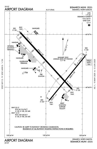
Runway 13/31
Dimensions:
8,794 × 150 ft
(2,680 × 46 m)
(2,680 × 46 m)
Weight Bearing Cap:
Single wheel: 130,000 lbs
Double wheel: 180,000 lbs
Double tandem: 340,000 lbs
Double wheel: 180,000 lbs
Double tandem: 340,000 lbs
Surface:
asphalt, concrete, grooved, in good condition
Runway Edge Lights:
High
Comments:
n/a
| Designator: | 13 | 31 |
| Elevation: | 1,654.6 ft | 1,645.2 ft |
| Heading: | 131° magnetic 138° true | 311° magnetic 318° true |
| Gradient: | 0.11% down | 0.11% up |
| Traffic Pattern: | Left Pattern | Left Pattern |
| Markings: | precision, in Good condition | precision, in Good condition |
| Approach Lighting: |
|
|
| Displaced Threshold: | n/a | n/a |
| ILS/LOC: | ILS | ILS/DME |
| Obstructions: | Pole, 688 ft Left ft of center, 43 ft high, 1,662 ft from end, 34:1 clearance slope | n/a |
| Comments: | n/a | n/a |
Runway 03/21
Dimensions:
6,600 × 100 ft
(2,012 × 30 m)
(2,012 × 30 m)
Weight Bearing Cap:
Single wheel: 130,000 lbs
Double wheel: 180,000 lbs
Double tandem: 340,000 lbs
Double wheel: 180,000 lbs
Double tandem: 340,000 lbs
Surface:
asphalt, grooved, in good condition
Runway Edge Lights:
High
Comments:
n/a
| Designator: | 03 | 21 |
| Elevation: | 1,660.6 ft | 1,661.3 ft |
| Heading: | 032° magnetic 039° true | 212° magnetic 219° true |
| Gradient: | 0.01% up | 0.01% down |
| Traffic Pattern: | Not provided. Assume LEFT traffic pattern | Not provided. Assume LEFT traffic pattern |
| Markings: | precision, in Good condition | precision, in Good condition |
| Approach Lighting: |
|
|
| Displaced Threshold: | n/a | n/a |
| ILS/LOC: | n/a | n/a |
| Obstructions: | n/a | n/a |
| Comments: | Resa Nstd. FAA | Resa Nstd. FAA |
TFRs
Location: BIS
Please verify all content below using the FAA TFR Search Site or with a flight briefer.
TFR count: 0
NOTAMs
Location: BIS
Please verify all content below using the FAA NOTAM Search Site or with a flight briefer.
NOTAM count: 10 (Partial list shown. Expand to see full list HERE.)
| Number: | Start Date: (UTC) | End Date: (UTC) | Condition: |
|---|---|---|---|
| 4/2226 | 12/05/2024 1512 | IAP BISMARCK MUNI, BISMARCK, ND.
RNAV (GPS) RWY 3, AMDT 2B...
LPV VIS 1 ALL CATS. TEMPORARY CONSTRUCTION EQU… | |
| 05/037 | 05/16/2025 1914 | 05/17/2025 1914 | RWY 03 FICON 5/5/5 100 PCT WET OBS AT 2505161914. |
| 05/012 | 05/11/2025 0724 | 06/25/2025 0723 | OBST TOWER LGT (ASR 1038537) 463955.00N1004634.00W (6.6NM S BIS) 2106.0FT (440.9FT AGL) U/S |
| 02/681 | 02/27/2025 1446 | NAV ILS RWY 13 OM U/S | |
| 04/168 | 04/15/2025 1839 | 07/08/2025 1700 | TWY C BTN TWY A2 AND PAX TERMINAL RAMP CLSD |
| 05/036 | 05/16/2025 1914 | 05/17/2025 1914 | RWY 31 FICON 5/5/5 100 PCT WET OBS AT 2505161914. |
| 04/164 | 04/14/2025 0550 | 05/29/2025 0549 | OBST TOWER LGT (ASR 1037188) 463055.00N1004806.00W (15.6NM S BIS) 2158.8FT (279.9FT AGL) U/S |
| 05/017 | 05/14/2025 1502 | 06/28/2025 1501 | OBST TOWER LGT (ASR 1219513) 465057.40N1002718.60W (12.8NM ENE BIS) 2102.0FT (349.1FT AGL) U/S |
Additional Remarks
Deer, Coyotes & Birds on & In vicinity of Arpt.
Source:
FAA
Federal Aviation Administration
For Cd If Una to CTC on FSS Freq, CTC Minneapolis ARTCC at 651-463-5588.
Source:
FAA
Federal Aviation Administration
Rmks-Arng: Opr 1200-2130Z++ Mon-Fri Exc Hol, Prior Permission Required 24 Pn Rqr Dsn 373-4071/70, C701-3334071/70. Fw Pax Trml Lctd in 'se' Hgr.
Source:
FAA
Federal Aviation Administration
Noise Abatement
Instrument Procedures
Operations & More Information
Lat/Long:
- 46.77273, -100.74574
- 46° 46′ 21.8″ N, 100° 44′ 44.7″ W
- 46° 46.364′ N, 100° 44.744′ W
ARTCC:
Minneapolis (ZMP)
App/Depart Control Facility:
Unknown
Chart:
NACO: Twin Cities Sectional
FSS:
Grand Forks (GFK)
1-800-WX-BRIEF
1-800-WX-BRIEF
Wind Indicator:
Lighted
Mag Var:
07E (2010)
NOTAM Facility:
Seg Circle:
No
Beacon:
Present
Lighting:
Pilot Activated Lighting:
- low intensity: 3 clicks in 2 secs
- medium intensity: 5 clicks in 2 secs
- high intensity: 7 clicks in 2 secs
AM
When Air Traffic Control Tower Clsd HIRL Rys 13/31 & 03/21 Preset Med Intst; PAPI Rys 13; 31; 03; & 21 On; Actvt Mals Ry 13 & MALSR Ry 31 - CTAF.
FAA
Pattern Altitude:
No data provided. Assume 1000 AGL.
Special Operations:
Communications Card
| Type: | Frequency / Phone: | Sector / Comments: | Call Sign: |
|---|---|---|---|
| Approach/Departure | 126.3 | Bismarck | |
| ARNG OPS | 134.1 | Bismarck | |
| ARNG OPS | 49.8 | Bismarck | |
| ASOS | (701) 922-9747 | Bismarck | |
| ATIS | 119.35 | Bismarck | |
| CTAF | 118.3 | Bismarck | |
| Emergency | 121.5 | Bismarck | |
| Ground Control | 121.9 | Bismarck | |
| Tower | 118.3 | Bismarck | |
| UNICOM | 122.95 | Bismarck |
Navaids
Services
Fuel:
100LL Low-Lead, Jet A
AM
Engine Repair:
Major
AM
Airframe Repair:
Major
AM
Bottled Oxygen:
None
Bulk Oxygen:
High/Low
AM
Customs:
None
Transportation:
Courtesy Transportation, Limousine, Public Transportation
AM
Activities:
None Reported
Camping On Field:
None Reported
Aircraft & Activity
Webcams
METARs
METARs from this airport:
METARs from nearby reporting stations:
TAFs
TAFs from this airport:
KBIS TAF
Issued:
5:35 PM GMT
(3 hours ago)
Today 6:00 PM - 9:00 PM GMT
Vis:
6
SM
Wind:
@
25
G
39
KT
Cld:
- Overcast 1500' AGL
Wx:
Light Rain, Mist
Today 9:00 PM - Tomorrow 2:00 AM GMT
Vis:
5
SM
Wind:
@
24
G
41
KT
Cld:
- Overcast 1000' AGL
Wx:
Light Rain, Mist
Tomorrow 2:00 AM - 5:00 AM GMT
Vis:
6
SM
Wind:
@
18
G
28
KT
Cld:
- Overcast 900' AGL
Wx:
Light Rainshowers, Mist
Tomorrow 5:00 AM - 10:00 AM GMT
Tomorrow 10:00 AM - 5:00 PM GMT
Tomorrow 5:00 PM - 6:00 PM GMT
Vis:
6+
SM
Wind:
@
9
KT
Cld:
- Scattered clouds 7000' AGL
Wx:
N/A
TAFs from nearby airports:
Contact Addresses
Airport Manager
Gregory B Haug
Bismarck, ND 58502-0991
(701) 355-1808 (Office)
Owner
City of Bismarck
Bismarck, ND 58502
(701) 355-1808 (Office)
Remarks:
24Hr Contact: Operations 701-220-9885.
FAA
Airport Reviews
Nearby Events
- No nearby events found.
Travel Articles
- Pilots flying from the East or West coast headed to EAA AirVenture Oshkosh in Wisconsin can fill up their bellies and fuel up their aircraft with discounts at friendly airports along the way.
