FAA Information Effective: Apr 17, 2025
All information is provided from the FAA unless otherwise noted.
(KBHM) Birmingham-Shuttlesworth International Airport
1 rating | 1 review
Overview
Attendance:
Attended
Year-round, 7 Days a Week,All
FAA
Elevation:
650 ft (Surveyed)
Tower:
Mil Ops Hrs: 0700-1730 TUE-SUN
FAA
Primary Approach Control Hrs: 24
FAA
Primary Depart. Control Hrs: 24
FAA
Tower Hrs: 24
FAA
Airspace:
C
Fees:
Parking, Other
Click FBO link(s) below for details:
Atlantic Aviation West
Click FBO link(s) below for details:
FBO Fee Details:
Atlantic Aviation EastAtlantic Aviation West
Timezone:
CDT (UTC-05:00)
Sunrise-Sunset:
5:51 am - 7:37 pm
Evening-Morning Civil Twilight:
8:05 pm
(Today)
(Today)
-
5:23 am
(Tomorrow)
(Tomorrow)
Minimum Fuel Prices:
$7.11
100LL (full)
$6.91
Jet-A (full)
$7.60
Jet-A-Premix/Prist (full)
Runway
Satellite
Sectional
FBOs
Submit New FBO
Atlantic Aviation East
No ratings | Be the first to review this business
Services Offered:
Car Rental
$7.11 | 100LL | full
$7.45 | Jet-A | full
$7.60 | Jet-A-Premix/Prist | full
Location:
On field: E
Phone:
(205) 591-6830
Freq. Monitored:
ASRI: 130.575
Fees:
Parking, Other
Atlantic Aviation West
No ratings | Be the first to review this business
Services Offered:
Car Rental
$7.30 | 100LL | full
$6.91 | Jet-A | full
Location:
On field: W
Phone:
(205) 849-5520
Freq. Monitored:
ASRI: 131.975
Fees:
Parking, Other
Flight Training
Submit New Flight School
Other businesses
Submit New Business
AOPA Travel Discounts 
FlightBridge is the ultimate all-in-one travel booking platform built for the general aviation community. AOPA Members receive free access to FlightBridge with AOPA discounted rates automatically applied. Members save an average of 30% on hotel bookings! Learn more about FlightBridge HERE.
Local Food/Lodging/Activities
Local Attractions
Local Activities
Restaurants
Hotels and Lodging
Travel Discounts
4343 73rd St North, Birmingham, AL 35206
(205) 833-8226
BHM
Southern Museum of Flight
Flying Clubs
Submit New Flying Club
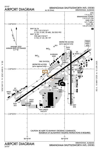
Runway 06/24
Dimensions:
12,007 × 150 ft
(3,660 × 46 m)
(3,660 × 46 m)
Weight Bearing Cap:
Single wheel: 120,000 lbs
Double wheel: 250,000 lbs
Double tandem: 485,000 lbs
Dual double tandem: 992,000 lbs
Double wheel: 250,000 lbs
Double tandem: 485,000 lbs
Dual double tandem: 992,000 lbs
Surface:
asphalt, grooved, in good condition
Runway Edge Lights:
High
Comments:
Pcr Value: 1102/F/D/X/T
FAA
| Designator: | 06 | 24 |
| Elevation: | 603.4 ft | 650 ft |
| Heading: | 058° magnetic 055° true | 238° magnetic 235° true |
| Gradient: | 0.39% up | 0.39% down |
| Traffic Pattern: | Left Pattern | Left Pattern |
| Markings: | precision, in Fair condition | precision, in Fair condition |
| Approach Lighting: |
|
|
| Displaced Threshold: | n/a | 1,205 ft |
| ILS/LOC: | ILS | ILS/DME |
| Obstructions: | Trees, 654 ft Right ft of center, 58 ft high, 1,290 ft from end, 18:1 clearance slope | Terrain, 610 ft Right ft of center, 67 ft high, 1,323 ft from end, 16:1 clearance slope |
| Comments: | n/a | Apch Slope 25:1 Due to 44 Ft Pole, 4424 Ft from Dsplcd Thr. FAA Malsr Air Traffic Control Tower Ctld, Operations Ummonitored. FAA Navaid Shelter 149 Ft Fm Rwy End, 405 Ft L, 1 Ft Abv Rwy End Elev. FAA |
Runway 18/36
Dimensions:
7,099 × 150 ft
(2,164 × 46 m)
(2,164 × 46 m)
Weight Bearing Cap:
Single wheel: 105,000 lbs
Double wheel: 143,000 lbs
Double tandem: 197,000 lbs
Double wheel: 143,000 lbs
Double tandem: 197,000 lbs
Surface:
asphalt, grooved, in good condition
Runway Edge Lights:
Medium
Comments:
Pcr Value: 440/F/D/X/T
FAA
| Designator: | 18 | 36 |
| Elevation: | 644.3 ft | 633.5 ft |
| Heading: | 183° magnetic 180° true | 003° magnetic 000° true |
| Gradient: | 0.15% down | 0.15% up |
| Traffic Pattern: | Left Pattern | Left Pattern |
| Markings: | non-precision, in Good condition | non-precision, in Good condition |
| Approach Lighting: |
|
|
| Displaced Threshold: | n/a | n/a |
| ILS/LOC: | LOC/DME | n/a |
| Obstructions: | Trees, 883 ft Right ft of center, 245 ft high, 5,689 ft from end, 22:1 clearance slope | Trees, 210 ft Left ft of center, 62 ft high, 1,340 ft from end, 18:1 clearance slope |
| Comments: | n/a | n/a |
TFRs
Location: BHM
Please verify all content below using the FAA TFR Search Site or with a flight briefer.
TFR count: 0
NOTAMs
Location: BHM
Please verify all content below using the FAA NOTAM Search Site or with a flight briefer.
NOTAM count: 44 (Partial list shown. Expand to see full list HERE.)
| Number: | Start Date: (UTC) | End Date: (UTC) | Condition: |
|---|---|---|---|
| 03/124 | 03/31/2025 1200 | 06/04/2025 2300 | OBST RIG (ASN 2024-ASO-9971-NRA) 333325N0864618W (1.1NM WSW BHM) 626FT (25FT AGL) FLAGGED AND LGTD |
| 12/165 | 12/30/2024 1928 | 12/31/2025 2300 | TWY H2 CLSD TO ACFT WINGSPAN MORE THAN 105FT |
| 03/126 | 03/25/2025 1200 | 06/04/2025 2300 | OBST RIG (ASN 2024-ASO-9985-NRA) 333322N0864622W (1.1NM WSW BHM) 624FT (25FT AGL) FLAGGED AND LGTD |
| 05/021 | 05/02/2025 0215 | 07/30/2025 0400 | OBST TOWER LGT (ASR 1009819) 332824.00N0863439.00W (10.2NM ESE BHM) 1000.0FT (270.0FT AGL) U/S |
| 04/169 | 04/29/2025 2017 | 05/31/2025 2300 | APRON TERMINAL RAMP WEST CENTRAL ACCESS NONMOVEMENT AREA BDRY MARKINGS NOT STD |
| 05/076 | 05/09/2025 0641 | 05/10/2025 1000 | TWY G APCH AREA HLDG PSN SIGN FOR APCH END RWY 36 LGT U/S |
| 05/085 | 05/11/2025 0039 | 05/12/2025 0039 | RWY 36 FICON 5/5/5 100 PCT WET OBS AT 2505110039. |
| 03/130 | 03/31/2025 1200 | 06/04/2025 2300 | OBST RIG (ASN 2024-ASO-9989-NRA) 333319N0864642W (1.4NM WSW BHM) 627FT (25FT AGL) FLAGGED AND LGTD |
Additional Remarks
Ang: Prior Permission Required Rqr for Ang Ramp. Nml Opr Hrs 1300-2330Z++ Tue-Fri, Clsd Wknds & Hol. No Svc Avbl Outside These Hrs Without Prior Apvl. No Lcl or Round-Robin Flt by Tran Acft. Call Airfield Operations Dsn 778-2555, C205-714-2555 for Prior Permission Required 72 Hr Prior (96 Hrs for Cargo Msn). All Inbd Acft CTC Ang Comd Post "Vulcn Control" No Later Than 15 Min Prior to Ldg with Prior Permission Required NR and Support Req. Space-A Capabilities Extremely Ltd, Pax Svc Ltd Availability.
Source:
FAA
Federal Aviation Administration
Bird Actv In vicinity of Rwys.
Source:
FAA
Federal Aviation Administration
Twy A between Twy A Hldg Bay and Twy A3 Rstrd to Acft with Wingspan Less Than 150 Ft.
Source:
FAA
Federal Aviation Administration
Twy F between Rwy 18/36 & Twy G Rstrd to Acft 100000 Lbs or Less.
Source:
FAA
Federal Aviation Administration
Twy G Rstrd to Acft 65000 Lbs or Less.
Source:
FAA
Federal Aviation Administration
Twy H S of Twy H4 Rstrd to Acft with Wingspan Less Than 118 Ft.
Source:
FAA
Federal Aviation Administration
Twy H2 Rstrd to Acft with Wingspan Less Than 105 Ft.
Source:
FAA
Federal Aviation Administration
Twy H3 Rstrd to Acft with Wingspan Less Than 105 Ft.
Source:
FAA
Federal Aviation Administration
Twy M N of Rwy 6/24 Rstrd to Acft 75000 Lbs or Less.
Source:
FAA
Federal Aviation Administration
Twy N Rstrd to Acft 204000 Lbs or Less.
Source:
FAA
Federal Aviation Administration
Noise Abatement
Instrument Procedures
Data Cycle:
Operations & More Information
Lat/Long:
- 33.56389, -86.75231
- 33° 33′ 50.0″ N, 86° 45′ 8.3″ W
- 33° 33.833′ N, 86° 45.138′ W
ARTCC:
Atlanta (ZTL)
App/Depart Control Facility:
Unknown
Chart:
NACO: Atlanta Sectional
FSS:
Anniston (ANB)
1-800-WX-BRIEF
1-800-WX-BRIEF
Wind Indicator:
Lighted
Mag Var:
03W (2010)
NOTAM Facility:
Seg Circle:
No
Beacon:
Present
Lighting:
No lighting reported.
Pattern Altitude:
No data provided. Assume 1000 AGL.
Special Operations:
Communications Card
| Type: | Frequency / Phone: | Sector / Comments: | Call Sign: |
|---|---|---|---|
| Approach/Departure | 127.675 | 231-049 | Birmingham |
| Approach/Departure IC | 123.8 | 050-230 | Birmingham |
| ASOS | (205) 591-6172 | Birmingham | |
| ATIS | 119.4 | Birmingham | |
| CD PRE TAXI CLNC | 125.675 | Birmingham | |
| CLASS C | 123.8 | 050-230 | Birmingham |
| CLASS C | 127.675 | 231-049 | Birmingham |
| Emergency | 121.5 | Birmingham | |
| Ground Control | 121.7 | Birmingham | |
| Tower | 119.9 | Birmingham | |
| Tower(S) | 118.25 | Birmingham | |
| UNICOM | 122.95 | Birmingham |
Navaids
Services
Fuel:
100LL Low-Lead, Jet A
AM
Engine Repair:
Major
AM
Airframe Repair:
Major
AM
Bottled Oxygen:
None
Bulk Oxygen:
High/Low
AM
Customs:
International Landing Rights
AM
Transportation:
Courtesy Transportation, Limousine, Public Transportation, Shuttle Service
AM
Activities:
None Reported
Camping On Field:
None Reported
Aircraft & Activity
Webcams
METARs
METARs from this airport:
METARs from nearby reporting stations:
TAFs
TAFs from this airport:
KBHM TAF
Issued:
11:26 PM GMT
(2 hours ago)
Today 12:00 AM - 4:00 AM GMT
Vis:
6
SM
Wind:
@
11
G
22
KT
Cld:
- Broken clouds 900' AGL
Wx:
Light Rainshowers
Today 4:00 AM - 3:00 PM GMT
Today 3:00 PM - 6:00 PM GMT
Vis:
6+
SM
Wind:
@
9
KT
Cld:
- Broken clouds 600' AGL
Wx:
Showers in vicinity
Today 6:00 PM - Tomorrow 12:00 AM GMT
Vis:
6
SM
Wind:
@
10
KT
Cld:
- Broken clouds 1100' AGL
Wx:
Rainshowers
Today 6:00 PM - Tomorrow 12:00 AM GMT
PROB30
Vis:
4
SM
Wind:
Cld:
- Overcast 1200' AGL
Wx:
Thunderstorm, Rain
TAFs from nearby airports:
KEET TAF
23 nm S
Issued:
11:26 PM GMT
(2 hours ago)
Today 12:00 AM - 3:00 AM GMT
Vis:
6
SM
Wind:
@
12
KT
Cld:
- Broken clouds 900' AGL
Wx:
Light Rainshowers
Today 12:00 AM - 1:00 AM GMT
TEMPO
Vis:
4
SM
Wind:
@
12
KT
Cld:
- Overcast 900' AGL
Wx:
Thunderstorm, Rain
Today 3:00 AM - 4:00 PM GMT
Today 4:00 PM - 6:00 PM GMT
Vis:
6+
SM
Wind:
@
8
KT
Cld:
- Broken clouds 600' AGL
Wx:
Showers in vicinity
Today 6:00 PM - Tomorrow 12:00 AM GMT
Vis:
6
SM
Wind:
@
9
KT
Cld:
- Broken clouds 1100' AGL
Wx:
Rainshowers
Today 6:00 PM - Tomorrow 12:00 AM GMT
PROB30
Vis:
4
SM
Wind:
Cld:
- Overcast 1100' AGL
Wx:
Thunderstorm, Rain
KASN TAF
35 nm E
Issued:
11:26 PM GMT
(2 hours ago)
Today 12:00 AM - 3:00 AM GMT
Vis:
6
SM
Wind:
@
13
G
23
KT
Cld:
- Broken clouds 1100' AGL
Wx:
Light Rainshowers
Today 3:00 AM - 6:00 PM GMT
Vis:
6+
SM
Wind:
@
11
KT
Cld:
- Broken clouds 800' AGL
Wx:
Showers in vicinity
Today 6:00 PM - Tomorrow 12:00 AM GMT
Vis:
6
SM
Wind:
@
9
KT
Cld:
- Overcast 1100' AGL
Wx:
Rainshowers
Today 6:00 PM - Tomorrow 12:00 AM GMT
PROB30
Vis:
2
SM
Wind:
Cld:
- Overcast 1000' AGL
Wx:
Thunderstorm, Rain
KTCL TAF
48 nm SW
Issued:
11:26 PM GMT
(2 hours ago)
Today 12:00 AM - 2:00 AM GMT
Vis:
5
SM
Wind:
@
12
KT
Cld:
- Broken clouds 1200' AGL
Wx:
Light Rainshowers, Thunderstorm in vicinity
Today 2:00 AM - 8:00 AM GMT
Vis:
6+
SM
Wind:
@
12
KT
Cld:
- Broken clouds 900' AGL
Wx:
Showers in vicinity
Today 8:00 AM - 4:00 PM GMT
Today 4:00 PM - 6:00 PM GMT
Vis:
6+
SM
Wind:
@
8
KT
Cld:
- Broken clouds 800' AGL
Wx:
Showers in vicinity
Today 6:00 PM - Tomorrow 12:00 AM GMT
Vis:
6
SM
Wind:
@
8
KT
Cld:
- Broken clouds 1100' AGL
Wx:
Rainshowers
Today 6:00 PM - Tomorrow 12:00 AM GMT
PROB30
Vis:
2
SM
Wind:
Cld:
- Overcast 1000' AGL
Wx:
Thunderstorm, Rain
Contact Addresses
Airport Manager
Ronald Mathieu
Birmingham, AL 35212
(205) 599-0505 (Office)
Owner
Birmingham Airport Authority
Birmingham, AL 35212
(205) 599-0505 (Office)
Airport Reviews
Overall:
1 rating | 1 review
Runways and Taxiways:
Markings and Signage:
Ground Transportation:No ratings
Sort By:
- 12/29/19Good airportCharles B.A generally fine airport with the usual slight hassles for general aviation mixing with commercial jets. Approach control did a poor job of sequencing me with jets on arrival, and on departure I had to wait for traffic on a 3-mile final; and the 12,…
Nearby Events
- airshow
 Description:The North Alabama Airfest is an aviation event held at the Pryor Field Regional Airport (DCU), bringing together aviation enthusiasts, families, and thrill-seekers for a weekend of high-flying fun!