FAA Information Effective: Apr 17, 2025
All information is provided from the FAA unless otherwise noted.
(KASJ) Tri-County At Henry Joyner Field
No ratings | No reviews
Ahoskie, NC
(252) 345-0111
Overview
Attendance:
Attended
Year-round,Mon-Sat/0900-Dusk
FAA
Year-round,Sun/Unattended
FAA
Runways:
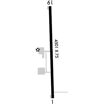
01/19
Runway length: 4,501 ft (1,372 m)
Elevation:
67 ft (Surveyed)
Tower:
No
Airspace:
Unknown
Fees:
Landing, Ramp, Tie Down, Other
Click FBO link(s) below for details:
Click FBO link(s) below for details:
FBO Fee Details:
Tri-County Airport AuthorityTimezone:
EDT (UTC-04:00)
Sunrise-Sunset:
6:12 am - 8:00 pm
Evening-Morning Civil Twilight:
8:28 pm
(Today)
(Today)
-
5:43 am
(Tomorrow)
(Tomorrow)
Minimum Fuel Prices:
$6.40
100LL (full)
$5.86
100LL (self)
$5.38
Jet-A-Premix/Prist (full)
$4.74
Jet-A-Premix/Prist (self)
Runway
Satellite
Sectional
FBOs
Submit New FBO
Tri-County Airport Authority
No ratings | Be the first to review this business
Services Offered:
Car Rental
$6.40 | 100LL | full
$5.86 | 100LL | self
$5.38 | Jet-A-Premix/Prist | full
$4.74 | Jet-A-Premix/Prist | self
Location:
On field: SW
Phone:
(252) 345-0111
Freq. Monitored:
UNICOM: 122.8
Fees:
Landing, Ramp, Tie Down, Other
Flight Training
Submit New Flight School
Other businesses
Submit New Business
AOPA Travel Discounts 
FlightBridge is the ultimate all-in-one travel booking platform built for the general aviation community. AOPA Members receive free access to FlightBridge with AOPA discounted rates automatically applied. Members save an average of 30% on hotel bookings! Learn more about FlightBridge HERE.
Local Food/Lodging/Activities
Local Attractions
Local Activities
Restaurants
Hotels and Lodging
Travel Discounts
Flying Clubs
Submit New Flying Club
Runway 01/19
Dimensions:
4,501 × 75 ft
(1,372 × 23 m)
(1,372 × 23 m)
Weight Bearing Cap:
Single wheel: 35,000 lbs
Double wheel: 45,000 lbs
Double wheel: 45,000 lbs
Surface:
asphalt, no surface treatment, in good condition
Runway Edge Lights:
Medium
Comments:
n/a
| Designator: | 01 | 19 |
| Elevation: | 66.5 ft | 66.3 ft |
| Heading: | 368° magnetic 358° true | 188° magnetic 178° true |
| Gradient: | n/a | n/a |
| Traffic Pattern: | Left Pattern | Left Pattern |
| Markings: | non-precision, in Good condition | non-precision, in Good condition |
| Approach Lighting: |
|
|
| Displaced Threshold: | n/a | n/a |
| ILS/LOC: | n/a | n/a |
| Obstructions: | Road, Both-Sides, 15 ft high, 437 ft from end, 15:1 clearance slope | Trees, 292 ft Left ft of center, 71 ft high, 973 ft from end, 10:1 clearance slope |
| Comments: | n/a | n/a |
TFRs
Location: ASJ
Please verify all content below using the FAA TFR Search Site or with a flight briefer.
TFR count: 0
NOTAMs
Location: ASJ
Please verify all content below using the FAA NOTAM Search Site or with a flight briefer.
NOTAM count: 9 (Partial list shown. Expand to see full list HERE.)
| Number: | Start Date: (UTC) | End Date: (UTC) | Condition: |
|---|---|---|---|
| 04/003 | 04/15/2025 2000 | 08/13/2025 2000 | OBST TOWER LGT (ASR 1004930) 362654.30N0771834.10W (11.1NM NW ASJ) 531.8FT (419.9FT AGL) U/S |
| 4/5769 | 12/12/2024 1550 | IAP TRI-COUNTY AT HENRY JOYNER FLD, AHOSKIE, NC.
RNAV (GPS) RWY 1, ORIG...
CHART PROFILE NOTE: VGSI AND RNAV… | |
| 01/007 | 01/28/2025 1853 | RWY 19 PAPI UNUSABLE | |
| 04/005 | 04/17/2025 2306 | 06/01/2025 0200 | OBST TOWER LGT (ASN 2008-ASO-873-OE) 362351N0765302W (15.2NM ENE ASJ) 224FT (210FT AGL) U/S |
| 04/006 | 04/22/2025 0509 | 06/06/2025 0542 | OBST TOWER LGT (ASN 2008-ASO-872-OE) 362304N0765254W (15.0NM ENE ASJ) 224FT (210FT AGL) U/S |
| 04/004 | 04/16/2025 1241 | RWY 01 PAPI U/S | |
| 05/002 | 05/02/2025 1403 | 06/02/2025 2359 | OBST TOWER LGT (ASR 1007790) 361647.00N0770158.00W (6.7NM E ASJ) 364.2FT (301.8FT AGL) U/S |
| 05/004 | 05/05/2025 0244 | 09/02/2025 0244 | OBST TOWER LGT (ASR 1290031) 361109.00N0771402.90W (7.5NM SSW ASJ) 395.0FT (310.0FT AGL) U/S |
Additional Remarks
For Clearance Delivery Contact Washington ARTCC at 703-771-3587.
Source:
FAA
Federal Aviation Administration
Rwy 01/19 -4 Ft Ditch 120 Ft L & R of Cntrln.
Source:
FAA
Federal Aviation Administration
Noise Abatement
Instrument Procedures
Data Cycle:
Operations & More Information
Lat/Long:
- 36.29753, -77.17085
- 36° 17′ 51.1″ N, 77° 10′ 15.1″ W
- 36° 17.852′ N, 77° 10.251′ W
ARTCC:
Washington (ZDC)
App/Depart Control Facility:
Unknown
Chart:
NACO: Washington Sectional
FSS:
Raleigh (RDU)
1-800-WX-BRIEF
1-800-WX-BRIEF
Wind Indicator:
Lighted
Mag Var:
10W (2000)
NOTAM Facility:
Seg Circle:
Yes
Beacon:
Present
Lighting:
Pilot Activated Lighting:
- low intensity: 3 clicks in 5 secs
- medium intensity: 5 clicks in 5 secs
- high intensity: 7 clicks in 5 secs
AM
Actvt REIL Rwy 01 & 19; MIRL Rwy 01/19 - CTAF. PAPI Rwy 01 & 19 Oper Consly.
FAA
Pattern Altitude:
No data provided. Assume 1000 AGL.
Special Operations:
Communications Card
| Type: | Frequency / Phone: | Sector / Comments: | Call Sign: |
|---|---|---|---|
| AWOS-3 | 119.075T (252) 345-2967 | ||
| Clearance Delivery Phone | (703) 771-3587 | Washington ARTCC | |
| CTAF | 122.8 | ||
| UNICOM | 122.8 |
Navaids
Services
Fuel:
100LL Low-Lead, Jet A1 +Icing Inhibitor
AM
Engine Repair:
None
Airframe Repair:
None
Bottled Oxygen:
None
Bulk Oxygen:
None
Customs:
None
Transportation:
Courtesy Transportation
AM
Activities:
None Reported
Camping On Field:
None Reported
Aircraft & Activity
Webcams
METARs
TAFs
Contact Addresses
Airport Manager
Henry Joyner
Aulander, NC 27805
(252) 345-0111 (Office)
Owner
Tri-County Airport Authority
Aulander, NC 27805
(252) 345-9962 (Office)
Remarks:
For Airport Airport Manager After Hours Call 252-395-0822.
FAA