FAA Information Effective: May 15, 2025
All information is provided from the FAA unless otherwise noted.
(F44) Athens Municipal Airport
1 rating | 1 review
Athens, TX
(903) 675-0066
Overview
Attendance:
Attended
Year-round, 7 Days a Week,0800-Dusk
FAA
Runways:
18/36
Runway length: 3,988 ft (1,216 m)
Elevation:
444 ft (Surveyed)
Tower:
No
Airspace:
Unknown
Fees:
Landing, Tie Down, Other
Click FBO link(s) below for details:
Dyson Aviation
Click FBO link(s) below for details:
FBO Fee Details:
Adco AviationDyson Aviation
Timezone:
CDT (UTC-05:00)
Sunrise-Sunset:
6:19 am - 8:25 pm
Evening-Morning Civil Twilight:
8:52 pm
(Today)
(Today)
-
5:51 am
(Tomorrow)
(Tomorrow)
Minimum Fuel Prices:
$4.80
100LL (full)
$3.84
Jet-A-Premix/Prist (full)
$4.51
100LL (self)
Runway
Satellite
Sectional
FBOs
Submit New FBO
Adco Aviation
1 rating | 1 review
Services Offered:
Car Rental
$4.51 | 100LL | self
$4.79 | Jet-A-Premix/Prist | full
Location:
On field: SW
Phone:
(903) 675-0086
Freq. Monitored:
UNICOM: 123
Fees:
Tie Down, Other
Dyson Aviation
No ratings | Be the first to review this business
Services Offered:
Maintenance
Plane Rental
$4.80 | 100LL | full
$3.84 | Jet-A-Premix/Prist | full
Location:
On field: CTR
Phone:
(903) 681-3294
Freq. Monitored:
UNICOM: 123
Fees:
Landing, Tie Down, Other
Flight Training
Submit New Flight School
Other businesses
Submit New Business
AOPA Travel Discounts 
FlightBridge is the ultimate all-in-one travel booking platform built for the general aviation community. AOPA Members receive free access to FlightBridge with AOPA discounted rates automatically applied. Members save an average of 30% on hotel bookings! Learn more about FlightBridge HERE.
Local Food/Lodging/Activities
Local Attractions
Local Activities
Restaurants
Hotels and Lodging
Travel Discounts
Flying Clubs
Submit New Flying Club
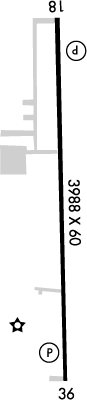
Runway 18/36
Dimensions:
3,988 × 60 ft
(1,216 × 18 m)
(1,216 × 18 m)
Weight Bearing Cap:
Single wheel: 25,000 lbs
Surface:
asphalt, no surface treatment, in good condition
Runway Edge Lights:
Medium
Comments:
n/a
| Designator: | 18 | 36 |
| Elevation: | 438.3 ft | 436.9 ft |
| Heading: | 178° magnetic 180° true | 358° magnetic 360° true |
| Gradient: | 0.04% down | 0.04% up |
| Traffic Pattern: | Left Pattern | Right Pattern |
| Markings: | non-precision, in Fair condition | non-precision, in Fair condition |
| Approach Lighting: |
|
|
| Displaced Threshold: | n/a | n/a |
| ILS/LOC: | n/a | n/a |
| Obstructions: | Fence, 225 ft Left ft of center, 5 ft high, 200 ft from end | Trees, 247 ft Right ft of center, 47 ft high, 200 ft from end, 1:1 clearance slope |
| Comments: | 11 Ft Road 0-200 Ft Fm Thr 240 Ft L. FAA | 12-25 Ft Trees on Fenceline 0-200 Ft Dstc, 247 R. FAA |
TFRs
Location: F44
Please verify all content below using the FAA TFR Search Site or with a flight briefer.
TFR count: 0
NOTAMs
Location: F44
Please verify all content below using the FAA NOTAM Search Site or with a flight briefer.
NOTAM count: 5
| Number: | Start Date: (UTC) | End Date: (UTC) | Condition: |
|---|---|---|---|
| 05/782 | 05/27/2025 0442 | 06/11/2025 0342 | OBST TOWER LGT (ASR 1269330) 315758.80N0960141.90W (15.7NM SW F44) 620.1FT (330.1FT AGL) U/S |
| 04/779 | 04/27/2025 0432 | 06/11/2025 0431 | OBST TOWER LGT (ASN 2022-ASW-18315-OE) 322324N0954148W (15.1NM NNE F44) 725FT (200FT AGL) U/S |
| 05/880 | 05/29/2025 1007 | 06/30/2025 2359 | OBST TOWER LGT (ASR 1322172) 321945.70N0955052.00W (9.96NM N F44) 810FT (319FT AGL) U/S |
| 05/508 | 05/18/2025 0047 | 09/15/2025 0047 | OBST TOWER LGT (ASR 1214695) 320829.70N0960444.50W (12.9NM W F44) 707.0FT (415.0FT AGL) U/S |
| 05/762 | 05/26/2025 1341 | 09/23/2025 1341 | OBST TOWER LGT (ASR 1269151) 321336.30N0955246.60W (4.6NM NW F44) 823.5FT (304.8FT AGL) U/S |
Additional Remarks
Feral Hogs on and In vicinity of Arpt.
Source:
FAA
Federal Aviation Administration
For Clearance Delivery Contact Fort Worth ARTCC at 817-858-7584.
Source:
FAA
Federal Aviation Administration
Noise Abatement
Instrument Procedures
Data Cycle:
Operations & More Information
Lat/Long:
- 32.16385, -95.82835
- 32° 9′ 49.9″ N, 95° 49′ 42.1″ W
- 32° 9.831′ N, 95° 49.701′ W
ARTCC:
Fort Worth (ZFW)
App/Depart Control Facility:
Unknown
Chart:
NACO: Dallas-Ft Worth Sectional
FSS:
Fort Worth (FTW)
1-800-WX-BRIEF
1-800-WX-BRIEF
Wind Indicator:
Lighted
Mag Var:
02E (2020)
NOTAM Facility:
Seg Circle:
Yes
Beacon:
Present
Lighting:
No lighting reported.
Pattern Altitude:
No data provided. Assume 1000 AGL.
Special Operations:
Communications Card
| Type: | Frequency / Phone: | Sector / Comments: | Call Sign: |
|---|---|---|---|
| AWOS-3PT | 119.6T (903) 670-1247 | ||
| Clearance Delivery Phone | (817) 858-7584 | Fort Worth ARTCC | |
| CTAF | 123.0 | ||
| UNICOM | 123.0 |
Navaids
Services
Fuel:
100LL Low-Lead, Jet A
AM
Engine Repair:
Major
AM
Airframe Repair:
Major
AM
Bottled Oxygen:
High/Low
AM
Bulk Oxygen:
None
Customs:
None
Transportation:
Courtesy Transportation
AM
Activities:
None Reported
Camping On Field:
None Reported
Aircraft & Activity
Webcams
METARs
TAFs
Contact Addresses
Airport Manager
Tim Perry
Athens, TX 75751
(903) 675-0066 (Office)
Owner
City of Athens
Athens, TX 75751
(903) 675-5131 (Office)
Remarks:
Public Works Director.
FAA
Airport Reviews
Overall:
1 rating | 1 review
Runways and Taxiways:
Markings and Signage:
Ground Transportation:No ratings
Sort By:
- 3/28/24Check ahead!Charles B.Dyson advertised a low price for JetA and opening at 7:30 in the morning. When I arrived 19 March, no one showed up at 0730 and when I called at 0745 they said they show up most days in the morning, but had no jet fuel for sale. Addco has self-serv…