FAA Information Effective: Apr 17, 2025
All information is provided from the FAA unless otherwise noted.
(KCLL) Easterwood Field
1 rating | 2 reviews
Overview
Attendance:
Attended
Year-round, 7 Days a Week,0600-2200
FAA
Elevation:
321 ft (Surveyed)
Tower:
Tower Hrs: 0800-2100
FAA
Airspace:
CLASS D SVC 0800-2100; OTHER TIMES CLASS E
FAA
Fees:
Timezone:
CDT (UTC-05:00)
Sunrise-Sunset:
6:36 am - 8:10 pm
Evening-Morning Civil Twilight:
8:36 pm
(Today)
(Today)
-
6:09 am
(Tomorrow)
(Tomorrow)
Minimum Fuel Prices:
$7.05
100LL (full)
$6.07
Jet-A (full)
$6.19
Jet-A-Premix/Prist (full)
Runway
Satellite
Sectional
FBOs
Submit New FBO
Astin Aviation
No ratings | Be the first to review this business
Services Offered:
Car Rental
$7.05 | 100LL | full
$6.07 | Jet-A | full
$6.19 | Jet-A-Premix/Prist | full
Location:
On field: E
Phone:
(979) 775-5255
Freq. Monitored:
UNICOM: 122.95
Fees:
Ramp, Other
Flight Training
Submit New Flight School
Other businesses
Submit New Business
AOPA Travel Discounts 
FlightBridge is the ultimate all-in-one travel booking platform built for the general aviation community. AOPA Members receive free access to FlightBridge with AOPA discounted rates automatically applied. Members save an average of 30% on hotel bookings! Learn more about FlightBridge HERE.
Local Food/Lodging/Activities
Local Attractions
Local Activities
Restaurants
Hotels and Lodging
Travel Discounts
1770 George Bush Dr W, College Station, TX 77845
(979) 775-9925
1000 George Bush Dr W, College Station, TX 77845
(979) 691-4000
400 Bizzell St, College Station, TX 77843
(979) 845-3211
CLL
Gate 12 Bar & Grill
George H.W. Bush Presidential Library and Museum
Texas A&M University
Flying Clubs
Submit New Flying Club
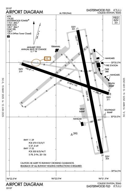
Runway 17/35
Dimensions:
7,000 × 146 ft
(2,134 × 45 m)
(2,134 × 45 m)
Weight Bearing Cap:
Single wheel: 78,000 lbs
Double wheel: 94,000 lbs
Double tandem: 156,000 lbs
Double wheel: 94,000 lbs
Double tandem: 156,000 lbs
Surface:
asphalt, concrete, grooved, in excellent condition
Runway Edge Lights:
High
Comments:
First 1850 Ft Rwy 35 Conc.
FAA
Pcr Value: 300/R/D/W/T
FAA
| Designator: | 17 | 35 |
| Elevation: | 320.6 ft | 304.3 ft |
| Heading: | 166° magnetic 169° true | 346° magnetic 349° true |
| Gradient: | 0.23% down | 0.23% up |
| Traffic Pattern: | Left Pattern | Left Pattern |
| Markings: | precision, in Good condition | precision, in Good condition |
| Approach Lighting: |
|
|
| Displaced Threshold: | n/a | n/a |
| ILS/LOC: | n/a | ILS/DME |
| Obstructions: | Tree, 480 ft Right ft of center, 42 ft high, 500 ft from end, 7:1 clearance slope | n/a |
| Comments: | n/a | n/a |
Runway 11/29
Dimensions:
5,158 × 150 ft
(1,572 × 46 m)
(1,572 × 46 m)
Weight Bearing Cap:
Single wheel: 37,000 lbs
Double wheel: 49,000 lbs
Double wheel: 49,000 lbs
Surface:
asphalt, grooved, in excellent condition
Runway Edge Lights:
Medium
Comments:
Pcr Value: 570/F/D/X/T
FAA
| Designator: | 11 | 29 |
| Elevation: | 319.4 ft | 311.4 ft |
| Heading: | 106° magnetic 109° true | 286° magnetic 289° true |
| Gradient: | 0.16% down | 0.16% up |
| Traffic Pattern: | Left Pattern | Left Pattern |
| Markings: | non-precision, in Good condition | non-precision, in Good condition |
| Approach Lighting: |
|
|
| Displaced Threshold: | n/a | n/a |
| ILS/LOC: | n/a | n/a |
| Obstructions: | Tree, 400 ft Right ft of center, 40 ft high, 1,180 ft from end, 24:1 clearance slope | Tree, 230 ft Left ft of center, 18 ft high, 500 ft from end, 17:1 clearance slope |
| Comments: | n/a | n/a |
TFRs
Location: CLL
Please verify all content below using the FAA TFR Search Site or with a flight briefer.
TFR count: 0
NOTAMs
Location: CLL
Please verify all content below using the FAA NOTAM Search Site or with a flight briefer.
NOTAM count: 7
| Number: | Start Date: (UTC) | End Date: (UTC) | Condition: |
|---|---|---|---|
| 04/047 | 05/01/2025 1200 | 06/01/2025 0100 | AIRSPACE UAS WI AN AREA DEFINED AS 6.6NM RADIUS OF 303536N0961705W (4.1NM E CLL) SFC-400FT AGL DLY 1200-0100 |
| 12/001 | 12/03/2024 1109 | NAV ILS RWY 35 OM U/S | |
| 05/003 | 05/02/2025 1613 | 08/01/2025 0400 | OBST TOWER LGT (ASR 1039472) 303323.70N0961520.80W (5.9NM ESE CLL) 529.2FT (223.1FT AGL) U/S |
| 03/029 | 03/31/2025 1216 | 06/28/2025 0132 | AIRSPACE UAS WI AN AREA DEFINED AS 1.5NM RADIUS OF
83TX (6.8NM WNW CLL) SFC-400FT AGL MON-FRI SR-SS |
| 5/4346 | 05/02/2025 1130 | IAP EASTERWOOD FLD, COLLEGE STATION, TX.
ILS OR LOC RWY 35, AMDT 14B...
LOC BC RWY 17, AMDT 8A...
RNAV (GPS)… | |
| 5/7705 | 05/08/2025 1349 | IAP EASTERWOOD FLD, COLLEGE STATION, TX.
RNAV (GPS) RWY 35, AMDT 1C...
LNAV/VNAV DA 619/HAT 308 ALL CATS.
FO… | |
| 05/005 | 05/07/2025 1008 | 08/05/2025 0400 | OBST TOWER LGT (ASR 1002417) 303815.70N0962409.80W (3.6NM NW CLL) 564.0FT (229.0FT AGL) U/S |
Additional Remarks
(Contact Phone Nr) Cabbott@Easterwoodairport.Com
Source:
FAA
Federal Aviation Administration
All Acft Prkg on Southeast Ramp Must CTC Astin Aviation for Svc or Trnsp, UNICOM 122.95 or 979-775-5255.
Source:
FAA
Federal Aviation Administration
All Rapid Rfl Mil Hel Adz Atc for Rapid Rfl Operations & Procd to South Ramp. CTC Astin Aviation UNICOM 122.95 for Svc Prior to Lndg. Rapid Rfl is Avbl 0600-2200 Dly. Spl Rqs Csdrd on Case by Case Basis.
Source:
FAA
Federal Aviation Administration
For Cd If Una to CTC on FSS Freq, CTC Houston ARTCC at 281-230-5622.
Source:
FAA
Federal Aviation Administration
Paew Adj All Rwys and Twys 0600-1600.
Source:
FAA
Federal Aviation Administration
Sfc Cond not Rprtd Fm 1700-0500 Lca Mon-Fri and Sat-Sun.
Source:
FAA
Federal Aviation Administration
Turn Fee Skedd Far 135 and All Far 121 Opns.
Source:
FAA
Federal Aviation Administration
Clsd to Unsked Acr Operations with More Than 30 Psgr Seats Excp 24 Hrs Prior Permission Required Call Airport Manager 979-775-9920.
Source:
FAA
Federal Aviation Administration
Noise Abatement
Instrument Procedures
Operations & More Information
Lat/Long:
- 30.58804, -96.36254
- 30° 35′ 17.0″ N, 96° 21′ 45.2″ W
- 30° 35.283′ N, 96° 21.753′ W
ARTCC:
Houston (ZHU)
App/Depart Control Facility:
I90
Chart:
NACO: Houston Sectional
FSS:
Montgomery County (CXO)
1-800-WX-BRIEF
1-800-WX-BRIEF
Wind Indicator:
Lighted
Mag Var:
03E (2020)
NOTAM Facility:
Seg Circle:
Yes
Beacon:
Present
Lighting:
Pilot Activated Lighting:
- low intensity: 3 clicks in 5 secs
- medium intensity: 5 clicks in 5 secs
- high intensity: 7 clicks in 5 secs
AM
When Air Traffic Control Tower Clsd Actvt MALSR Rwy 35; MIRL Rwy 11/29; HIRL Rwy 17/35 - CTAF. REIL Rwy 29 Preset Low Intst Only.
FAA
Pattern Altitude:
No data provided. Assume 1000 AGL.
Special Operations:
Communications Card
| Type: | Frequency / Phone: | Sector / Comments: | Call Sign: |
|---|---|---|---|
| Approach/Departure | 134.3 | Houston | |
| ASOS | (979) 846-1708 | Easterwood | |
| ATIS | 126.85 | Easterwood | |
| Clearance Delivery | 128.7 | Easterwood | |
| Clearance Delivery | 120.4 | WHEN TWR CLSD | Houston |
| CTAF | 118.5 | Easterwood | |
| Emergency | 121.5 | Easterwood | |
| Ground Control | 128.7 | Easterwood | |
| Tower | 118.5 | Easterwood | |
| UNICOM | 122.95 | Easterwood |
Navaids
Services
Fuel:
100LL Low-Lead, Jet A
AM
Engine Repair:
Major
AM
Airframe Repair:
Major
AM
Bottled Oxygen:
None
Bulk Oxygen:
None
Customs:
None
Transportation:
Courtesy Transportation
AM
Activities:
Intensive Flight Training, On field restaurant/café
AM
Camping On Field:
None Reported
Aircraft & Activity
Webcams
METARs
TAFs
Contact Addresses
Airport Manager
Kevin Davis
College Station, TX 77845
(979) 775-9901 (Office)
Owner
Texas A&M University System
College Station, TX 77840
(979) 775-9900 (Office)
Airport Reviews
Overall:
1 rating | 2 reviews
Runways and Taxiways:
Markings and Signage:
Ground Transportation:
Sort By:
- 4/26/21High Quality AirportPeter L.The company I fly for goes in and out of Easterwood Field seemingly weekly. It has high quality approaches to all of the runways and great service from the control tower. Astin Aviation is a beautiful FBO with good service and nice amenities. Gate 12…
- 10/7/16RICHARD C.A friend and I flew into Easterwood for a quick tour of A&M and a bite to eat. Astin Aviation was extremely welcoming and accommodating and offered us one of their courtesy cars. There seems to be countless restaurants to choose from so I'd highly re…