FAA Information Effective: May 15, 2025
All information is provided from the FAA unless otherwise noted.
(2G9) Somerset County Airport
1 rating | 2 reviews
Overview
Attendance:
Attended
Year-round, 7 Days a Week,0800-1600*
FAA
Elevation:
2,275 ft (Surveyed)
Tower:
No
Airspace:
Unknown
Fees:
Timezone:
EDT (UTC-04:00)
Sunrise-Sunset:
5:56 am - 8:32 pm
Evening-Morning Civil Twilight:
9:03 pm
(Today)
(Today)
-
5:24 am
(Tomorrow)
(Tomorrow)
Minimum Fuel Prices:
$6.00
100LL (self)
$5.35
Jet-A (self)
$5.35
Jet-A-Premix/Prist (self)
Runway
Satellite
Sectional
FBOs
Submit New FBO
Somerset County Airport
No ratings | Be the first to review this business
Services Offered:
Car Rental
$6.00 | 100LL | self
$5.35 | Jet-A | self
$5.35 | Jet-A-Premix/Prist | self
Location:
On field: N
Phone:
(814) 445-1599
Freq. Monitored:
Fees:
Overnight, Other
Flight Training
Submit New Flight School
Other businesses
Submit New Business
AOPA Travel Discounts 
FlightBridge is the ultimate all-in-one travel booking platform built for the general aviation community. AOPA Members receive free access to FlightBridge with AOPA discounted rates automatically applied. Members save an average of 30% on hotel bookings! Learn more about FlightBridge HERE.
Local Food/Lodging/Activities
Local Attractions
Local Activities
Restaurants
Hotels and Lodging
Travel Discounts
(814) 445-5200
(814) 445-8860
Pine Oaks Camp Ground
(814) 445-4093
Mostoller's Country Corral
(814) 445-7281
Cheryl's Home Run Pizza
(814) 444-9523
2G9
Town of Somerset PA
Somerset Country Club
Woodland Campsites
Pine Oaks Camp Ground
United Flight 93 Memorial
Mostoller's Country Corral
Cheryl's Home Run Pizza
Flying Clubs
Submit New Flying Club
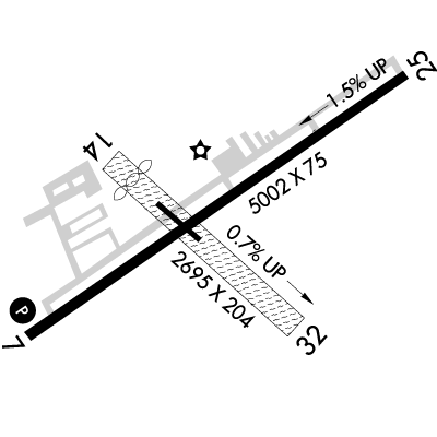
Runway 07/25
Dimensions:
5,002 × 75 ft
(1,525 × 23 m)
(1,525 × 23 m)
Weight Bearing Cap:
Single wheel: 18,000 lbs
Surface:
asphalt, no surface treatment, in good condition
Runway Edge Lights:
Medium
Comments:
n/a
| Designator: | 07 | 25 |
| Elevation: | 2,275 ft | 2,201.6 ft |
| Heading: | 066° magnetic 056° true | 246° magnetic 236° true |
| Gradient: | 1.47% down | 1.47% up |
| Traffic Pattern: | Left Pattern | Left Pattern |
| Markings: | non-precision, in Fair condition | non-precision, in Fair condition |
| Approach Lighting: |
|
|
| Displaced Threshold: | n/a | n/a |
| ILS/LOC: | n/a | Localizer |
| Obstructions: | n/a | Pole, 180 ft Left ft of center, 18 ft high, 544 ft from end, 19:1 clearance slope |
| Comments: | n/a | n/a |
Runway 14/32
Dimensions:
2,729 × 150 ft
(832 × 46 m)
(832 × 46 m)
Weight Bearing Cap:
n/a
Surface:
turf, grass, sod, no surface treatment, in good condition
Runway Edge Lights:
n/a
Comments:
617 Ft by 60 Ft Asph At Intxn with Rwy 07/25 & Parl Twy.
FAA
| Designator: | 14 | 32 |
| Elevation: | 2,227.8 ft | 2,255.4 ft |
| Heading: | 141° magnetic 131° true | 321° magnetic 311° true |
| Gradient: | 1.01% up | 1.01% down |
| Traffic Pattern: | Left Pattern | Left Pattern |
| Markings: | non-standard, in Good condition | non-standard, in Good condition |
| Approach Lighting: | n/a | n/a |
| Displaced Threshold: | 335 ft | n/a |
| ILS/LOC: | n/a | n/a |
| Obstructions: | Road, 124 ft Left ft of center, 16 ft high, 40 ft from end, 2:1 clearance slope | Trees, 74 ft Left ft of center, 25 ft high, 352 ft from end, 14:1 clearance slope |
| Comments: | 335 Ft Dthr Mkd with Yellow Cones. FAA 41 Ft Trees; 578 Ft Fm Der, 9 Ft Left. Approach Slp 22:1 Fm Dthr. FAA Road Angles Acrs Rcl. FAA Yellow Cones FAA | Yellow Cones FAA |
TFRs
Location: 2G9
Please verify all content below using the FAA TFR Search Site or with a flight briefer.
TFR count: 0
NOTAMs
Location: 2G9
Please verify all content below using the FAA NOTAM Search Site or with a flight briefer.
NOTAM count: 9 (Partial list shown. Expand to see full list HERE.)
| Number: | Start Date: (UTC) | End Date: (UTC) | Condition: |
|---|---|---|---|
| 5/6264 | 03/21/2025 1158 | IAP SOMERSET COUNTY, SOMERSET, PA.
RNAV (GPS) RWY 25, AMDT 1...
LNAV MDA 2640/HAT 400 ALL CATS, VIS CATS C/D… | |
| 01/106 | 01/09/2021 1523 | OBST POLE (ASN 2018-AEA-13809-OE) 400235N0790020W (0.5NM ENE 2G9) 2213FT (32FT AGL) NOT LGTD | |
| 5/6265 | 03/21/2025 1204 | IAP SOMERSET COUNTY, SOMERSET, PA.
RNAV (GPS) RWY 7, AMDT 1A...
CIRCLING CAT B MDA 2940/HAA 665..
2503211204… | |
| 05/244 | 05/22/2025 1841 | 06/01/2025 0300 | COM SEE ZOB 05/634 JOHNSTOWN APP CLR DELIVERY U/S |
| 05/167 | 05/16/2025 0223 | 06/15/2025 2359 | OBST TOWER LGT (ASR 1200400) 400559.30N0791334.10W (10.3NM WNW 2G9) 3072.8FT (274.9FT AGL) U/S |
| 01/107 | 01/09/2021 1524 | OBST POLE (ASN 2018-AEA-13810-OE) 400233N0790022W (0.5NM ENE 2G9) 2208FT (24FT AGL) NOT LGTD | |
| 01/108 | 01/09/2021 1525 | OBST POLE (ASN 2018-AEA-13811-OE) 400231N0790023W (0.5NM ENE 2G9) 2215FT (31FT AGL) NOT LGTD | |
| 04/181 | 04/17/2025 2025 | 07/16/2025 0400 | OBST TOWER LGT (ASR 1203440) 400055.10N0790343.60W (2.6NM WSW 2G9) 2499.0FT (307.1FT AGL) U/S |
Additional Remarks
For Clearance Delivery Contact Johnstown Approach at 814-532-5960, When Approach Clsd CTC Cleveland ARTCC at 440-774-0213.
Source:
FAA
Federal Aviation Administration
Rwy 14/32 Unusbl During Spring Thaw, Wet Periods & Snow; Check Notams.
Source:
FAA
Federal Aviation Administration
Noise Abatement
Instrument Procedures
Data Cycle:
Operations & More Information
Lat/Long:
- 40.03850, -79.01530
- 40° 2′ 18.6″ N, 79° 0′ 55.1″ W
- 40° 2.310′ N, 79° 0.918′ W
ARTCC:
Cleveland (ZOB)
App/Depart Control Facility:
JST
Chart:
NACO: Detroit Sectional
FSS:
Altoona (AOO)
1-800-WX-BRIEF
1-800-WX-BRIEF
Wind Indicator:
Lighted
Mag Var:
10W (2000)
NOTAM Facility:
Seg Circle:
Yes
Beacon:
Present
Lighting:
Pilot Activated Lighting:
- low intensity: 3 clicks in 5 secs
- medium intensity: 5 clicks in 5 secs
- high intensity: 7 clicks in 5 secs
AM
Mirl Rwy 07/25 & Twy Lgts on Dusk-0000; Actvt REIL Rwy 07/25, PAPI Rwy 07; Pvasi Rwy 25; - CTAF.
FAA
Pattern Altitude:
No data provided. Assume 1000 AGL.
Special Operations:
Communications Card
| Type: | Frequency / Phone: | Sector / Comments: | Call Sign: |
|---|---|---|---|
| Approach/Departure | 121.2 | Johnstown | |
| AWOS-3P | 133.8T (814) 443-2114 | ||
| Clearance Delivery Phone | (814) 532-5960 | Johnstown Approach | |
| Clearance Delivery Phone | (440) 774-0213 | When Approach Closed | Cleveland ARTCC |
| CTAF | 122.8 | ||
| UNICOM | 122.8 |
Navaids
Services
Fuel:
100LL Low-Lead, Jet A
AM
Engine Repair:
None
Airframe Repair:
None
Bottled Oxygen:
None
Bulk Oxygen:
None
Customs:
None
Transportation:
Courtesy Transportation
AM
Activities:
None Reported
Camping On Field:
None Reported
Aircraft & Activity
Webcams
METARs
TAFs
Contact Addresses
Airport Manager
David Wright
Friedens, PA 15541
(814) 445-1599 (Office)
Owner
Board of County Commissioners
Somerset, PA 15501
(814) 445-1400 (Office)
Airport Reviews
Overall:
1 rating | 2 reviews
Runways and Taxiways:
Markings and Signage:
Ground Transportation:No ratings
Sort By:
- 10/18/20Good fuel stop...Gerald S.Landed here for the first stop on the way back to Indiana. Great grass runway which was well marked. Mid-range fuel prices. They are starting major rehab of the fuel dump and digging up the in-ground tanks. They have Jet-A in a big truck and 100LL…
- 7/23/14HILLEL G.What a lovely place to stop! The airport manager got on the comm to update me on the winds and confirm our rental car while we were still on approach. He offered to bring the car to the plane and when we declined (since we didn't have much to carry) …