Hurricane Delta closes in on Gulf Coast
Category 3 storm bearing down on Louisiana-Texas border
The National Hurricane Center predicted Hurricane Delta, the Atlantic hurricane season’s twenty-fifth named storm and the tenth to threaten the United States, is taking aim on the Louisiana and Texas coasts, not far from where Hurricane Laura battered Louisiana’s Lake Charles Regional Airport only six weeks prior.
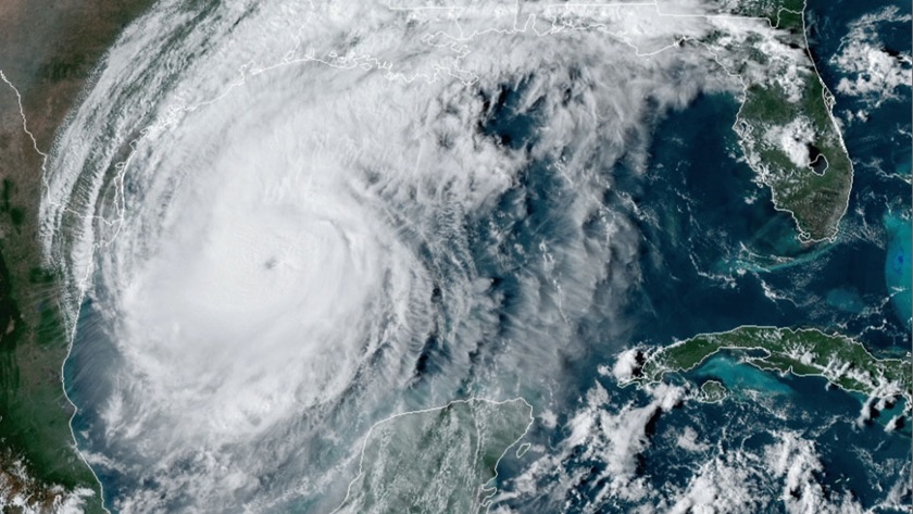
The hurricane was expected to make landfall October 9 as at least a Category 2 storm and possibly maintain the Category 3 strength it regained during the afternoon of October 8, before crashing ashore and spreading storm surge, rain, and wind damage through the central Gulf Coast and lower Mississippi Valley during the weekend.
According to FAA data, 56 piston aircraft, three jets, and 41 helicopters are based at Lake Charles Regional Airport.
“Hangars were completely destroyed, but we got lucky,” Thompson explained. One of the flight school’s two aircraft was at an Arkansas paint shop and another was repositioned at a nearby airport. “It was just dumb luck because our aircraft was OK and the one parked right next to it wasn’t. If we get another direct hit like that it could be bad.”
Hurricane Laura also damaged aircraft and property at Southland Field to the west.
The National Hurricane Center predicted tropical-storm-force winds would begin to batter the Gulf Coast from Texas to the Florida Panhandle by 8 p.m. on October 8. Forecasters warned of potential storm surge flooding from High Island, Texas, to Ocean Springs, Mississippi, with peak surges up to 11 feet near Vermilion Bay, Louisiana, south of the Lake Charles Regional Airport.
Hurricane-force winds were expected to arrive in the afternoon and evening of October 9 between High Island, Texas, and Morgan City, Louisiana, before spreading inland with “significant flash flooding” and minor to moderate river flooding, the weather service said.
GA gathers data on Hurricane Delta
In the days before landfall, National Oceanic and Atmospheric Administration “hurricane hunter” overflights included daily missions piercing parts of Hurricane Delta after departing from Florida’s Lakeland Linder International Airport, where a team of weather specialists and their aircraft are based.
A high-altitude Gulfstream IV–SP jet monitored upper atmosphere weather systems surrounding the developing hurricane while crews aboard a pair of four-engine turboprop Lockheed WP–3D Orion hurricane hunter aircraft named Kermit and Miss Piggy flew missions between 15,000 and 18,000 feet above the Gulf of Mexico.
The Orions are equipped with tail Doppler radar and lower fuselage radar systems to scan the storm vertically and horizontally, and also to perform reconnaissance missions into the storm’s center to measure central pressure and surface winds around the eye. The information is critical for authorities determining which communities need to evacuate in advance of the storm.
NOAA flight specialists can deploy weather data-gathering probes called dropwindsondes to support atmospheric and air chemistry studies. The devices report pressure, humidity, temperature, wind direction, and speed as they fall toward the sea and create a detailed picture of the storm’s intensity and structure.
The U.S. Air Force Reserve's 53rd Weather Reconnaissance Squadron flies Lockheed WC–130J aircraft from Keesler Air Force Base in Mississippi in support of similar missions. One aircraft flew into the Hurricane Delta eyewall as it made landfall on Mexico’s Yucatan peninsula while another evacuated to Texas, the service tweeted.
When winds increased by 85 mph in 24 hours during storm development it “more than doubled the criteria for the rapid intensification of a tropical cyclone, which is a wind speed increase of at least 35 mph in 24 hours or less,” The Weather Channel reported.
The “highest ocean heat content in the tropical Atlantic basin, low wind shear, and sufficiently moist air” contributed to the hurricane’s rapid intensification, the station’s meteorologists explained.
Hurricane Delta was expected to make a right turn to the northeast after landfall, but its future track was uncertain because of upper wind influences from another tropical storm system named Gamma.
“We’re hoping tomorrow we’ll have a place to bring the planes back to because people still want to learn how to fly and there’s still a shortage of flight instructors,” Thompson said.