VFR Unleashed: How to become an accident case study
Part Five of a multi-part series on expanding our horizons as VFR-only pilots
In the previous installment of VFR Unleashed, I told you about the time I made the conservative decision to detour 120 miles to avoid threading the needle between cloud cover and mountain peaks. Today, I want to tell you about the time I made the opposite choice just a few weeks later. It turned out to be a very flawed decision.

I was at the end of a weeklong VFR tour of the southeastern United States in a Cessna 182. I had flown a wide circle from Maryland through the Carolinas, across Georgia, down into Alabama, and back up through Tennessee. It was time to go home, and I was tired.
I was baffled at how any pilot could violate the cardinal law of VFR flying: Remain clear of clouds. It’s not like we can't see them coming. We know it's illegal to leave visual conditions during a VFR flight. Why do pilots get trapped by this? What tempts them to break that hard-and-fast barrier and knowingly fly into non-visual conditions?
Two weeks later, skimming mere feet below a solid layer of clouds with my heart pounding and the proverbial lump in my throat, I discovered precisely how some pilots get tempted into breaking that cardinal law. I looked at how close both the ceilings and the terrain had become, and the deteriorating visibility as spotty rain showers were developing, and I had a terrifying thought: “This is exactly how I become an accident case study video for the Air Safety Institute.” I could feel McSpadden’s disapproval if he knew where I was and what I was doing. I made one of those promises we make when we realize we are in serious trouble: “If I get out of this alive, I will never…”
 It should have been a simple 3.5-hour flight on a gorgeous day from Tullahoma, Tennessee, back home to Frederick, Maryland. The Cessna Skylane’s performance and fuel range meant that I could easily make the trip nonstop and be home before lunchtime. The summertime forecast had the potential for severe thunderstorms brewing in the region by midafternoon, so it was important to get the trip completed or I might get stuck on the road for at least another day or two.
I climbed to 11,500 feet msl to cruise above the scattered but growing cumulus clouds that were gathering along the western slopes of the Appalachians. All seemed pleasant, but about an hour into the flight, I noticed a few of the clouds below me were building rapidly, and a couple had grown well above my altitude. Part of McSpadden’s presentation had been about pilots getting trapped on top of rising cloud layers, so I was quite proud of myself when I told air traffic control I was going to turn around to go back to some clear air below and choose a lower altitude underneath the buildup.
Sadly, my wisdom ended there.
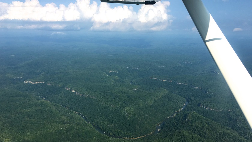
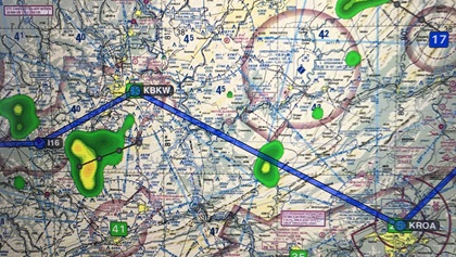
The problem I faced in decision making was the lack of reported conditions for about 40 miles of Appalachian wilderness along my route. My position offered nearly 3,000 feet of clearance between the clouds and the terrain. Forty miles east, Raleigh County Memorial Airport in Beckley, West Virginia, was reporting the same. ATC had no pilot reports, and there was no AWOS data available from the couple of small airports along the route.
Sometimes our get-there-itis can become even stronger when it’s at the end of a long trip, we are tired, and we just want to go home. The temptation to continue a trip into unknown conditions is one of the traps we can be easily lured into. Those risks might be less severe in flat areas of the country where many airports offer easy bail-out options for deteriorating weather—if we are prepared to make the choice to stop short when conditions call for it. But in mountainous or rural parts of the country where on-airport landing options simply may not exist, getting trapped between rising terrain and lowering ceilings can become deadly.
For the last 15 miles or so into Beckley, I had become pinched between the clouds and the mountain ranges with less altitude to spare than I am willing to confess in print. Turning back was not a wise option, as I had no idea if the clouds or developing rain showers had closed in along the 25 miles behind me. If I turned around, I could find myself in an even worse situation.
I began to prepare myself for the possibility that an off-airport landing—and the profound embarrassment that would be for me to report my whereabouts to AOPA’s flight operations department—could become my only option if the conditions deteriorated further. I imagine that most VFR pilots who find themselves trapped in these circumstances hesitate to consider landing off-airport, and it may be why some continue and end up entering the clouds. But all things considered, such a drastic and embarrassing option is still far better than hitting an obscured hillside.
Just as I was sorting through those options and making my internal vows to never do this again, Beckley came into view. I landed safely with trembling knees and a new resolve.
And I never have done that again.