Drone mapping for the rest of us
Maps and mosaics are among the most powerful products a drone camera can produce, but producers of polished, user-friendly software made for professionals aren’t giving freebies anymore. Open-source software offers hobbyists and soloists an affordable alternative.

The cloud must be brimming by now with pictures taken by drone pilots showing their own houses from various angles and altitudes. Take enough of these, and you’ll realize two things: First, you can only see so much from 400 feet, so if you happen to have more than an acre or two, you’re going to need a map. All of us have faced the difficulty of not being able to back up far enough with our camera phones to shoot group pictures. This is the aerial version of that dilemma, and where photogrammetry comes in.
DroneDeploy and Pix4D both offer slick, effective, and user-friendly products backed up by support in various forms, but the developers are capitalizing on the demand and pricing their products too steeply—into hundreds or thousands of dollars per year—to be affordable for training, or just fooling around with maps. Which, it turns out, is fun.
A web search for free or low-cost mapping solutions led me to one (among few) that I recently tested. It produced good results, satisfied my needs, and did not break the bank. Up front, this article explores this particular DIY option, with no attempt to compare it to others.
WebODM is an open-source application that runs on your computer, and acts as a web interface to the likewise open-source Open Drone Map software that has been around since 2014. WebODM allows the average non-programmer like me to access the Open Drone Map engine that analyzes images and renders your maps. WebODM has no limits on the number of projects you can create, and costs $57. (A command-line version of ODM is free, but since I drive a Mac, I sprang for the Mac web interface.)
A book by the developer of WebODM is a much-advised add-on. All in all, the software and manual cost less than some of the fast SD cards we load into our drones. The manual is not too technical for a casual reader, and does a good job of explaining photogrammetry, and what ODM does.
The software has a learning curve. Fortunately, there is a community of thousands in the WebODM forum comprising organizations and individuals around the world. There is no technical support number to call, which is not surprising in an open-source environment. Remember that you are not paying for a traditional corporate infrastructure with staff to manage the product and attend to your calls. Your successes, failures, and questions are welcome on the forum, where you can often find assistance from other users. If you want more direct access to customer support, support contract agreements are available.
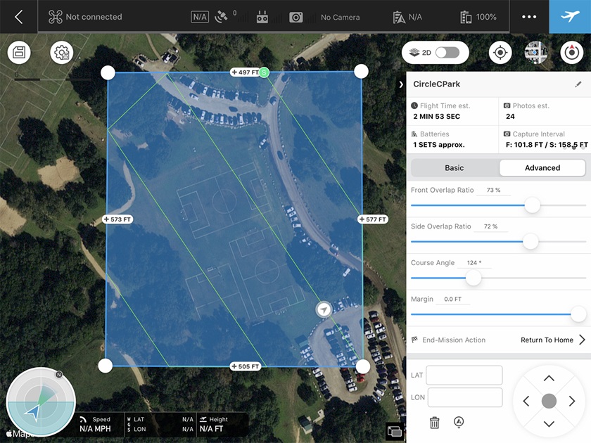
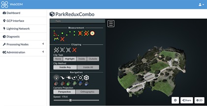
I tested WebODM with a set of 53 JPEGs taken with my Phantom 4 Pro at a neighborhood park. I flew a grid that I created in DJI Ground Station Pro, flying the camera at an altitude of about 350 feet. The specific altitude that works best depends on the desired resolution. Bear in mind that lower altitudes yield better resolution, but a lot more photos to process. The actual number of photos needed is determined by the desired resolution, the flight grid you build, and the overlap of images.
I pointed the camera straight down (referred to as the nadir view) and kept the required human eye on the Phantom as it danced around the soccer fields and park. Then, I flew the same grid at a different angle from the first, at a lower altitude, and with the camera raised about 30 degrees from the nadir view. The resulting 2D, orthorectified image (let’s call it the map) was a sharp and clear 1.2-GB file. It did indeed look like a satellite image, but with more detail. Switching to the 3D view, I felt like a kid in a toy store as I “spun” the park image around, looking at it from all sides and taking measurements from soccer fields and parking lots.
It’s fascinating to consider what a series of 2D photos became after the software finished its business.
Part of learning photogrammetry software includes experimenting with small changes in user-definable settings that can make significant differences in the final product. Making my own maps or 3D images felt like performing electrical work in the home without burning the house down. Plus, the files and resulting models never left my computer.
WebODM is not for older computers with less than 4 GB of RAM or hard drives smaller than 20 GB. (If you’re running one of those, we probably don’t need to talk about multicore processors and video cards capable of high-volume floating-point calculations. Just skip it, really.)
Considering variations in angles, light, altitude, and a host of other factors, combining the data from dozens or hundreds of images into one requires a ton of number crunching. Processing time varies, depending on the size and number of source images and the output desired.
According to Florida-based engineer Piero Toffanin, who wrote WebODM, photogrammetry is not actually “stitching” photos together as some panoramic software does. The algorithm must dig deeper than that, analyzing scenes from various camera placements in order to build spatial models. Working on a fast, multi-core laptop with 32 GB of RAM, my project finished in 45 minutes. I haven’t waited that long for an aviation product since the day the fuel truck got lost on the ramp. The final result was worth the wait—in both cases.
Toffanin’s web client has broadened the potential user base for Open Drone Map significantly.
Most drones embed GPS coordinates into their camera image’s EXIF file, and that data helps the software build the model. Good photogrammetry relies on proper image collection from your UAS as well as the backend software interpretation of the files. As IT professionals tell us, “Garbage in, garbage out.” Don’t expect to nail it on the first try.
Toffanin stresses that while we are societally conditioned to think expensive is better, all photogrammetry software is fundamentally similar. WebODM is not about bells and whistles, and lacks some feature sets and services the more expensive solutions offer. Still, Toffanin says, WebODM can produce a comparable product in many cases.
WebODM is worth a shot if you have the DIY gene, enough computer power at hand, and the desire (and time) to learn more about photogrammetry. I find it somewhat addictive and have only scratched the surface.