How an NTSB drone documented a B–17 crash
Agency innovates with common tools
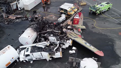
NTSB investigators flew a popular consumer quadcopter to document the recent Boeing B–17 Flying Fortress crash in Connecticut, providing the first aerial views of the tragic scene. The detailed data gathered in a series of flights at the state’s busiest airport may provide insight not achievable a few years ago.

Mike Bauer, a systems analyst and aerospace engineer, and member of the NTSB team that arrived at Bradley International Airport within hours of the October 2 crash, described the unmanned aircraft operations in detail in a telephone interview. A certificated private pilot and one of a handful of certificated remote pilots staffing an agency drone program assembled by senior investigator Bill English, Bauer has flown unmanned aircraft for many kinds of investigations.
Stitching still photographs into a map is the "bread-and-butter" of the NTSB drone program, but Bauer, English, and others at NTSB have found new ways to document key data that goes beyond those basics.
A brief clip taken by the DJI Phantom that Bauer flew was relayed to the agency’s media relations team for inclusion in a package of video released for public consumption on October 3, but that was a small fraction of the data Bauer collected. His flights began before investigators first approached the wreckage. (People, including investigators, stay clear of the area while the drone does its work for safety.) By the time that footage was posted on YouTube, Bauer’s drone had already collected enough still images to create an accurate 3D model of the wreckage, and a detailed digital map covering thousands of feet between the first approach light struck by the stricken warbird and its final resting place, along with video that will allow investigators to view and replay as many times as they need to the fateful final approach from the cockpit perspective.
Bauer said footage distributed for media use may also prove valuable to the investigation in the months to come. While on scene, the investigator-pilots can never be sure what detail might prove useful, so they work to digitize the scene as thoroughly as possible.
“Any bit of data I have is useful,” Bauer said. “While the video might be primarily for the media, or for the media folks to keep our message going, there’s things in that video that might give you a perspective that you didn’t think of, or, coupled with the map or the 3D model that you made … it might give you that one angle that you might not have captured.”
Bauer said photos were captured using automated flight plans created in Pix4D Capture, which has become a standard first step.
“Once we ensured we had the data captured over the actual the wreckage site, we were then able to give the wreckage site back to the accident investigative team,” Bauer said. “Then I moved from the accident site all the way back to first contact.”
A new perspective
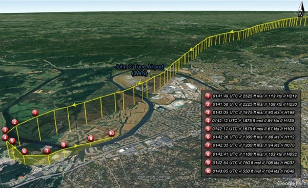
The vintage bomber had struggled to gain more than a few hundred feet of altitude, and struck approach lights about 1,000 feet short of the threshold of Runway 6, from which the crew had departed and was attempting to return, according to the agency’s preliminary report. While the images and footage captured by the drone will not alone solve the mystery, they provide investigators with “situational awareness,” Bauer said, a context for the accident that begins to impose order on chaotically scattered pieces of metal.
Bauer’s mission plan at Bradley included a new wrinkle, capturing a set of nadir images (taken with the camera pointing straight down) that could be quickly assembled into a digital map using a new tool, Pix4Dreact. That software is designed to minimize the processing time required to construct, using a laptop computer, a reasonably accurate overview of the area. This was the first time this particular software program had been used, and Bauer said the results were encouraging. “It was very positive … being able to get that orthomosaic and start building a wreckage model.”
As investigators began combing through the main wreckage site, Bauer repositioned for additional mapping flights to include the damaged approach lights and other “witness marks” left by the stricken bomber as it careened across the grass, onto the runway, and then veered toward deicing fluid storage tanks about 1,100 feet from the center of the runway threshold.
By the end of the first day, Bauer had enough images on his laptop, along with ground control point data collected with the aid of a high-precision Trimble Geo 7X GPS, to create a richly detailed orthomosaic map. While that particular model is not quite as precise as some used in the survey industry, it fits neatly in a backpack and “we can get within a couple of inches relative (accuracy) on the model, which is so much better than the old way of dragging a tape measure or using a wheel,” Bauer said.
Bauer said he, English, and the other drone-flying investigators of the NTSB decided early on that their drone kit had to fit in a backpack. “We don’t know where the accident site may be, or how to get there. Half our thing is trying to be mobile.”
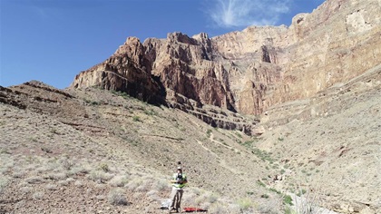
The ground control points (reference points captured in the photos that allow the software to correct GPS errors when assembling the maps and digital models) are generally marked with spray paint, a can of which also fits neatly in the backpack. He brought marked cards into the Grand Canyon to document the scene of a helicopter crash, because painting inside the national park is prohibited, but generally the paint works best. The backpack also carries the drone, controller, a laptop, and six batteries.
Flying a drone in the airspace of a busy Class C airport requires coordination, and Bauer said the FAA waiver request was initiated before the first investigators arrived on scene, with a Part 107 waiver approved by the FAA within hours. On the first day, Runway 6 was closed to traffic, making drone deconfliction a little easier. Bauer coordinated additional flights October 3 with the tower and airport manager, utilizing the aid of a visual observer and monitoring the tower frequency with a handheld radio.
“They ended up closing that runway for about 30 minutes” on October 3, Bauer said. “They just thought that was going to be easier.”
After a brief delay to allow a helicopter to depart, “NTSB Drone” took off. (The agency does not use a fancy call sign, though Bauer does name agency drones after racing airplanes flown at the National Championship Air Races in Reno, Nevada, and the drone flown at Bradley is Strega in the paperwork.) The next mission was to capture video that re-creates the cockpit perspective by programming the flight path for the drone based on recorded radar data of the accident flight. While this video of the final approach cannot perfectly replicate variations in pitch, roll, and yaw to exactly match the pilots’ perspective, it offers investigators another layer of situational awareness that would be difficult or impossible to capture and digitize by other means.
Bauer said another popular drone app, Litchi, is the flight control program of choice for that task, partly because it allows the user to focus the camera on the touchdown point, or another point of interest to investigators. Bauer parsed the approach into sections, flying a portion in each to maintain visual contact with the drone at all times. Aided by the visual observer and two-way communication with the tower, the flights were wrapped up with minimal delay to air traffic and a rich harvest of data for the rest of the investigation team.
“It worked out perfectly,” Bauer said. “No issues, everything was smooth as silk with the airport, with ATC. It was great.”
Flying over airports and inside controlled airspace has become relatively routine for the NTSB drone team, but every mission is conducted with great care. Bauer said the agency uses checklists adapted from generic checklists created and published by drone services company Kittyhawk, with a few items added that are specific to NTSB operations.
“You show up at the scene of an accident, there’s a lot of moving parts, there’s a lot of things going on, there’s a lot of people doing a lot of stuff. That checklist becomes invaluable,” Bauer said. “Your mind is racing.”
The data sets collected can vary, depending on the specifics of the accident. Bauer recalled one case where a drone helped create a 3D model of a hangar that allowed a computer simulation (based on computational fluid dynamics) of the airflow around a hangar, offering insight how wind affected a parked aircraft and damaged the elevator, leading to an accident. (A white paper documenting that case was published by the International Society of Air Safety Investigators.)
In another case, a helicopter’s collision with power lines was modeled and re-created in digital form. Insights from the B–17 investigation may emerge in the coming weeks or months that are unexpected, or particularly useful.
Bauer can envision new tools coming to bear on the data already collected. It’s possible that investigators in the future may be able to take a virtual reality walk around the scene, examining details preserved by images taken long before.
“Now, you have a 3D world, a virtual world, to look at,” Bauer said.
While far from the only tool that will be brought to bear, the off-the-shelf consumer drone Bauer flew, one of the most popular models in the world, may one day help save lives. That, Bauer said, remains the overarching mission of everything the NTSB does: learning the lessons of past tragedies to prevent future ones.
“The overall goal is to make aviation safer,” Bauer said.