Flying the trench
An incomparable alpine route across Canada

Ferry route, by the numbers
- Flight hours: 35
- Distance: 3,450 nautical miles
- Lowest cruising altitude: 1,000 feet in southwest Alaska
- Highest cruising altitude: 13,500 feet over the Rocky Mountains
- Slowest groundspeed: 48 knots
- Fastest groundspeed: 135 knots
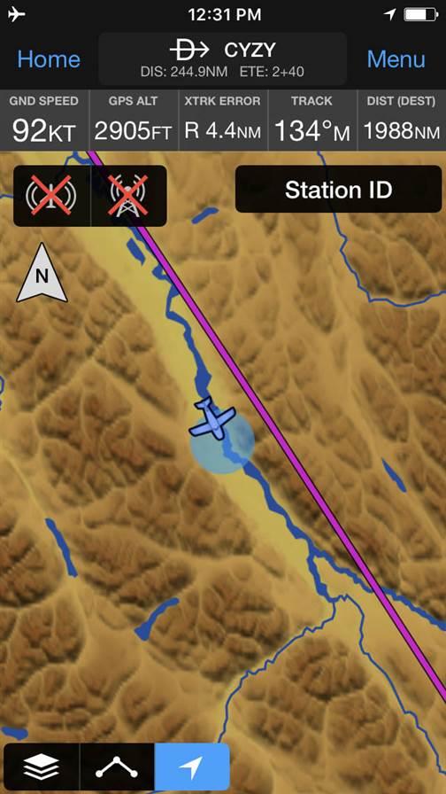
This iPhone screenshot shows a small portion of the Trench route (which almost perfectly aligns with the GPS-direct route in magenta). The Garmin Pilot app on the iPhone showed terrain in far greater detail than the airplane’s GNS 530 navigator.
Tips for flying in Canada:
- Get an international telephone plan before crossing into Canada. They only cost about $5 a day, and the costs are severe for telephone or data use without them.
- Get familiar with Canadian aviation procedures before going. Canada requires VFR or IFR flight plans for every flight, and radio procedures are different—especially at nontowered airports.
- Get old-school paper VFR sectionals for Canada. They show the preferred VFR routes that generally follow roads.
- Remember that most U.S. XM Weather subscriptions don’t cover Canada.
- Use your international calling plan to phone U.S. Customs before returning to the United States.
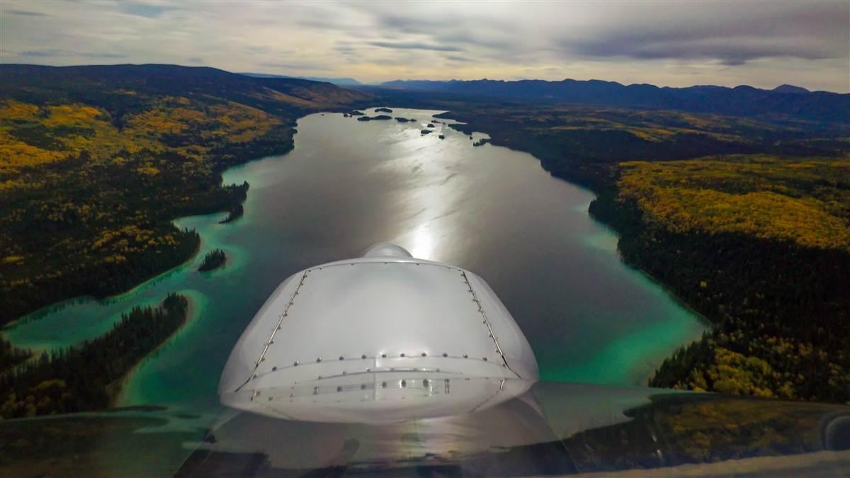
Once in the trench, a river and mountains on both sides make the route easy to follow. Autumn colors made for spectacular scenery, but the high cirrus clouds shown here were a harbinger of rain and low ceilings ahead.
Alaska Rainbow Lodge on the Kvichak River is closing for the season, and its three float Beavers soon will fly to winter maintenance in Wasilla, about 250 miles away. I’m about to begin a far longer journey in lodge owner Chip Ferguson’s Husky A–1B, taking it on a 3,450-nautical-mile odyssey through the incomparable Lake Clark Pass, over the “Trench” in British Columbia, eventually bringing it to Ferguson’s native Texas.
“This route will amaze you, challenge you, and totally wear you out,” said Ferguson, who has made the seasonal trip several times in this airplane. Pressing business and family matters prevent him from making the journey this time, and I jump at the chance to make the solo flight because it will take me on a route I’ve never flown before.
The Trench is a 600-mile-long route through a steep-sided valley that reaches from the Yukon Territory all the way to southern British Columbia. It’s a visually stunning pathway in a nearly direct northwest/southeast line between Alaska and the U.S. mountain west. The other routes for light general aviation aircraft flying between Alaska and the Lower 48 states are the coast—which is harsh, forbidding, and almost always cloudy—and the Alaska-Canada Highway, a seemingly endless ribbon of asphalt that’s mostly on the Canadian prairie.
“The Trench is way more interesting than the highway,” Ferguson said. “There are things to see every minute in the Trench. Mountains, valleys, fall colors, wildlife, and a few glaciers. It’s not dramatically shorter than the highway route, but there’s so much more to see. It’s my favorite way to go, by far.”
My own terms
Sitting at the kitchen table in the lodge, Ferguson talked about his Husky’s idiosyncrasies, techniques for hot starts, tire pressure preferences, and fuel consumption at various power settings. He filled me in on places to stay in towns along the way, camping sites (Watson Lake is the best), and refueling options. (They’ll give you an ice cream cone when you stop in Mackenzie.) His Husky is IFR equipped, with a Garmin GNS 530 and a six-pack, and I brought an iPhone running Garmin Pilot and a few paper charts.
Ferguson filled the rear of the airplane with survival gear: tent, sleeping bag, camp stove, bug repellent, bear spray, a rifle, freeze-dried food, a satellite messenger, and a first-aid kit. I brought a personal locator beacon and a battery pack that could recharge my electronic devices—and even jump the aircraft battery in a pinch.
Judging from the forecast, I expected to stay put for several days before beginning the flying marathon. But the morning of my second day there dawned sunny and cool with light winds, and Ken Strickler, chief pilot at Alaska Rainbow Lodge, said the weather looked favorable for the first leg to Anchorage and beyond.
The main attraction—and biggest obstacle—to VFR flying between southwest Alaska and Anchorage is the jaw-dropping Lake Clark Pass. It’s a massive rock and ice funnel with dizzying, nearly vertical walls that close to claustrophobic dimensions in the middle. There are webcams at key junctures in the pass, but two of them weren’t working on the morning I started my trip. I knew the weather was good on both sides of the pass, however, so I took off on the rutted, muddy strip and, to my great relief, the Husky lifted off in less than half of the rock-strewn surface’s 800-foot length.
During the hour-long flight to the pass, I monitored the party line frequency, 122.9 MHz, and asked whether any of the other pilots in the area had flown through the pass yet. None had. I checked in with Kenai Flight Service, and the news was sobering. A de Havilland Beaver pilot reported that the clouds went all the way to the ground near the middle of the pass, and he had turned around. I flew to within a few miles of the pass, then landed at a gravel strip to wait. As a newbie to Alaska flying, I wanted to defer to someone else.
I’d been on the ground about one hour when a pair of float Beavers flew eastward toward the pass at low altitude. Perhaps they’d learned the ceiling had lifted enough to get through. I fired up the Husky and followed them, asking again for pilot reports.
Instead of leading the way through the pass, however, the Beavers had landed at a seaplane base in Lake Clark before taking off again. Now, I’d get to the pass before they did. The pass was relatively clear at the entrance, and I flew into its wide mouth at about 2,500 feet. It was raining lightly and visibility was five miles or more. My groundspeed was only 75 knots, however, because a 20-knot headwind was blowing through the chasm.
The two Beaver pilots behind me were evaluating their options on 122.9 MHz and expressing doubts about the wisdom of pressing on. Then one reported an alternator failure and said he was turning back. The other decided to join him.
“I promised myself a long time ago that I’d only make this trip on my own terms—and these aren’t my terms,” he said. “I don’t need to go to town [Anchorage] that bad. No one does.”
“If something was going to break on this trip, be glad that it happened when and where it did,” said aircraft salvage expert Dee Wygant. “I’ve got more Husky parts than just about anyone outside Afton, Wyoming.”By this time, I was several miles into the pass and approaching “the narrows.” As the name implies, it’s the thinnest place on the route, and the highest elevation—and I didn’t like what I saw. The ceiling was getting lower, the rain was becoming heavier, and areas of fog began to appear on the braided river below. Time for a 180-degree turn. Soon I was headed back out of the wide canyon with a booming tailwind.
An air taxi pilot reported the cloud tops were 8,500 feet, and he had just overflown the pass in clear, smooth air. I took that same “high road,” and climbed to 11,500 feet. After about 60 miles above the clouds, the skies in Anchorage were clear and I dropped in at Palmer for fuel. Then I continued northeast following the lower elevations and planned to get within striking distance of the Canadian border before stopping for the night.
But as I overflew tiny Gulkana, Alaska, I felt a twang in the elevator control that abruptly moved the stick fore and aft, then all felt normal again. Had I hit a bird? Was I imagining things? I landed at Gulkana and saw that one of the streamlined, stainless steel wires that brace the tail had snapped in flight.
It was a Friday evening, and I figured I was about to spend the next five days or so in Gulkana. Aviat Aircraft would be closed for the weekend, and it was highly doubtful I’d be able to get a replacement part sent until it reopened on Monday.
About this time, Super Cub owners Leonard and Betty Viersen, both retired teachers, stopped by and asked what brought me to their local airport. I showed them the snapped wire and asked whether there was an aviation mechanic on the field. There wasn’t—but Leonard Viersen had another idea.
He called Dee Wygant, an aircraft restorer with an extensive collection of damaged bush airplanes. In less than 15 minutes, Wygant was on the phone.
“I’ve restored about five Huskys over the years and I’m 100 percent sure I’ve got the part you’re looking for,” Wygant told me. “I can’t come out tonight, but I can be there in the morning.”
True to his word, Wygant, an energetic Indiana transplant who has lived in Alaska since 1996, stopped by in his battle-scarred Ford 150 pickup wearing a Carhartt jacket. He replaced the broken part in 15 minutes, all the while telling macabre Alaska flying tales.
“This isn’t a very friendly part of the world to crash in,” the aircraft salvage expert said. “Lots of people have done it, and I don’t think any of them would recommend it.”
Wygant took a close look at the broken wire and surmised it had been nicked long ago by a piece of gravel. Over time, stress and vibration weakened it until the wire finally snapped.
I had visited an ATM to stock up on cash to pay Wygant, and his rate was surprisingly modest. “Let’s call it $100 for the part and $100 for driving out here on a Saturday morning,” he said. “If something was going to break on this trip, be glad that it happened when and where it did. I’ve got more Husky parts than just about anyone outside Afton, Wyoming.”

The Trench
Pilots in Alaska and northern Canada don’t follow roads just because of the low elevations. They do it because they’re much more likely be found in relatively well-traveled areas than in remote ones. And being even a few miles away from the highway radically decreases the odds of being found quickly. I follow the highway across the Alaska border to Whitehorse, Yukon, then on to Watson Lake. At Watson Lake, however, the road ends and the Trench begins. Flying southeast there’s only wilderness. Oval lakes and marshes fill the landscape, and a curvaceous river leads to the broad valley that gives the route its name.
The valley walls are far apart, more than 20 miles in many places. But the clarity of the mountain air and snow-capped peaks lining both sides make it seem narrower.
I listen on 126.7 MHz, the ubiquitous air-to-air frequency in Canada, but it is almost totally silent throughout the long, 350-nautical-mile leg to Mackenzie, British Columbia, the next airport where avgas is available. I’ve filled a pair of five-gallon fuel bladders with avgas at Watson Lake and, if necessary, I’ll land along the way and transfer the fuel to the Husky’s two 25-gallon wing tanks. There are a couple of gravel strips marked on the aeronautical charts. But a light tailwind and groundspeed in excess of 100 knots make me think that won’t be necessary.
A carpet of fiery red and yellow forest passes by underneath. There are no roads, power lines, or other signs of human habitation for many miles. I’m sharing the airspace with eagles, ducks, cranes, and nesting pairs of trumpeter swans. On the marshy ground, footprints of large animals—likely bears or moose—are plentiful and easy to spot, even from 1,000 feet agl. There’s one fork in the Trench where the main branch of the river goes left, but the GPS shows the proper course to follow is to the right. A couple hours into this solitary flight, the natural splendor becomes almost monotonous.
The skies have been blue for the first half of this flight, but a high cirrus appears after two hours, and the light tailwind changes to a stiff headwind. Groundspeed falls from 100 knots to 75, and a precautionary landing for fuel becomes a real possibility. Then a light rain begins to fall, and so does the ceiling.
The lakes get bigger over this section of the Trench; whitecaps and wind streaks indicate it’s blowing more than 20 knots on the surface, and a direct headwind. I start thinking through contingencies: I can land at a gravel strip on an Indian reservation, but I’ve been cautioned only to do so in an emergency, since I’m not likely to receive a warm welcome.
The Husky is equipped with 31-inch tires that would make it easy to land on a beach or sandbar. But if, for some reason, I’m unable to restart the engine, no one will know my whereabouts. I can avoid shutting down by keeping the engine idling and set the parking brake, but it’s easy to imagine things going wrong in this scenario. I continue recalculating my fuel reserves and ponder how stupid it would be to run out of gas with 10 unused gallons sitting in the baggage area.
Finally, the headwind relents, the rain eases, and my groundspeed increases. I land at Mackenzie with comfortable reserves after four hours, 20 minutes in the air, but it’s cloudy, spitting rain, and so cold ice cream doesn’t even sound tempting.
The forecast calls for dreary weather throughout the coming week, but there’s a good chance it will be better just an hour south at Prince George. The weather is technically VFR, but it’s raining so hard when I get near Prince George that I end up tracking the localizer needle for the last five miles and follow the ILS to landing.
From Prince George, the “lower” Trench follows the mountains to Cranbrook near the U.S. border. But the clouds are thick and low in that direction, and the weather briefer recommends a more favorable route to the southwest. I head that direction and land at Kelowna; then I file an eAPIS customs notification form and Canadian flight plan, cross the U.S. border near Omak, Washington, and land at Spokane International Airport to clear Customs.
The rest of the trip across the mountain west brings strong winds, rain, and turbulence. But the wind direction becomes favorable, and the sky clears near Salt Lake City. I stop at Spanish Fork, Utah, for the night. First light the next morning I catch a tailwind and ride it over the Four Corners, Albuquerque, and all the way to the airplane’s home base in the Dallas suburbs.
I started the trip wearing wool socks, a thermal undershirt, and jacket. In Texas, it’s 92 degrees on the ramp, and it feels like a different world. In 35 flight hours, ground speed ranged from 48 to 135 knots, and cruising altitudes were as low as 1,000 feet in southwest Alaska and as high as 13,500 feet over the Rocky Mountains. There were sublime moments— such as the first half of the Trench route—and worrisome ones, such as the second half of the same flight.
At the beginning of the five-day flight, I regarded it as a marathon, not a sprint. By the end, I realized it was really a series of sprints. Each leg was unique, and in total, they called upon just about every piece of aviation knowledge or skill I’d learned in many years of flying. They also introduced me to some colorful and resourceful characters I never would have met any other way.
I’d do it again tomorrow.
Email [email protected]

Dave Hirschman
Related Articles
