safety pilot landmark accident: vertical thinking
Deficient planning, no moving map lure CFI and student into terrain

The flight
November 8, 2014, was a nice autumn evening. A flight instructor and student pilot set out on a night cross-country in a Cessna 172. The student had laid out a plan to go from Frederick Municipal Airport in Maryland (FDK); around the Washington, D.C., restricted airspace to Winchester, Virginia (OKV), for some pattern work; and then on to Charlottesville, Virginia (CHO). The return to Frederick would be via the Linden VOR.
The instructor told the student that he was not certain of the elevation in the area because the airplane was not equipped with a Garmin G1000 navigation system.However, when the CFI and the student met at about 4 p.m. Eastern Standard Time, the CFI changed the destination to Hot Springs, Virginia (HSP). FAR 61.109 requires a night cross-country flight with more than 100 nautical miles between airports. Apparently the CFI belatedly determined that Charlottesville would not meet the requirement, but Hot Springs would suffice. Perhaps in the interest of time, the CFI did not have the student plan the new route, and no flight plan was filed.
After several landings at Winchester, the flight turned toward Hot Springs on a heading of 240 degrees at 3,000 feet msl. By this time the sun had set as the student and instructor entered mountainous terrain.
According to the NTSB’s post-accident interview, “The student asked the instructor about terrain elevation in the area, and the instructor responded that he was not certain of the elevations because the airplane was not equipped with a G1000 navigation system” (emphasis added). The student pilot reported that there were no aeronautical charts aboard for the western portion of the trip to the revised destination, although there was a Washington sectional tucked away in a map pocket.
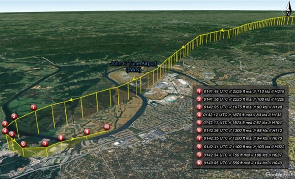
Everything proceeded routinely and at a GPS-indicated distance of 68 nautical miles from Hot Springs, the CFI demonstrated autopilot heading and altitude modes at 3,000 feet. The instructor selected a 200-feet-per-minute climb and then 500 fpm. The student mentioned the drop in airspeed from 120 knots to 90 knots and asked about adding power, which the CFI did.
The student recalled that it was “pitch black” outside as the aircraft started climbing, and then they crashed. They hit the ground about 3,100 feet msl, approximately 300 feet from the top of a ridge. The instructor died shortly after the crash. The student survived but was seriously injured.
The NTSB noted that an emergency locator transmitter (ELT) signal was received after the crash and passed along to an ATC facility by overflying aircraft—but the supervisor did not notify search and rescue, as required. Because the pilots had not filed a flight plan or requested VFR flight following, the rescue response took much longer. The wreck was not located until the following day.
Flight instructor and student
The 49-year-old CFI held an airline transport pilot certificate, issued in August 2010, with ratings for airplane single-engine land, multiengine land, and helicopter; and a commercial certificate with ratings for airplane single-engine sea, airplane multiengine sea, and glider. The instructor’s certificate was approved for airplane single-engine, multiengine, instrument, and glider operations. His total time was 5,941 hours, with 1,182 hours as a flight instructor and 410 total hours at night. His last flight review had been conducted a month before the accident.
The student pilot, age 51, had started taking lessons in August 2014 and had accumulated nearly 24 hours, with 22 in the Cessna 172. He had 4.5 hours at night but had not yet soloed.
The aircraft and weather
The 2003 Cessna 172S, with a 180-horsepower engine, had 4,263 hours and was equipped with conventional round-dial instruments, aka “steam gauges.” All inspections were current, and no preimpact malfunctions were noted. Weather was not a factor with clear skies and light winds.
NTSB findings
The National Transportation Safety Board determined the probable cause(s) of this accident to be: “The flight instructor’s decision to conduct a night training flight in mountainous terrain without conducting or allowing the student to conduct appropriate preflight planning and his lack of situational awareness of the surrounding terrain altitude, which resulted in controlled flight into terrain.”
Commentary
As mentioned, we get a valuable look into both pilots’ thought processes with the student’s survival—very unusual in a CFIT crash.
Had the student prepared a revised flight plan, perhaps terrain would have been considered. The sectional chart showed a maximum elevation figure of 5,100 feet, with a mountain near the accident location topping out at 3,700 feet. It sets a terrible example when instructors do not model the procedures they’re teaching. This would include not making any plan for the flight, not having appropriate charts, and not following the guidance that in mountainous terrain, to allow at least 2,000 feet of vertical clearance. Some would question the wisdom of flight over such inhospitable terrain in a single-engine aircraft after dark.
With no charts for the area, night conditions, and no terrain awareness, the outcome was predictable. In the post-crash interview, the student noted that he felt comfortable flying at night in a G1000-equipped Cessna 172 that he’d flown before because of the additional situational awareness provided. That aircraft was unavailable, so a conventionally equipped Cessna 172 was used for the accident flight.
The student said, “Everything got weird the night before the flight.” He called the CFI at approximately 8:30 p.m. the night before to discuss the plan, but the instructor’s wife said he had gone to bed. Around 7:30 a.m. the CFI emailed the student saying that the flight plan was good, and did not indicate any need to change destinations.
The report noted the “Student decided that all was OK because he trusted the CFI, so he continued on course and altitude.”
Glass cockpits can be a huge benefit, but perhaps it’s still a good idea to be able to fly without all the latest equipment. The electrons are seductive and basic skills erode.
Here’s a hypothesis on how the instructor managed to make such a fundamental mistake. Most basic flight instruction takes place close to the home airport, and as creatures of habit, many of us get what I’ll call an “altitude mindset.” Because terrain and obstructions are well known, we use a rote altitude for en-route VFR flight or maneuvers. In the relatively flat country around Frederick, especially if one doesn’t venture too far west, 3,000 feet generally will be sufficient for VFR operations. The highest terrain is around 1,700 feet. However, looking at the instrument charts—especially if one goes just a little farther west—the minimum en-route or off-route altitudes jump to 5,000 to 6,000 feet. The VFR maximum elevation figures (MEFs) rise significantly, as well.
When I’ve ventured west, I’ve had to consciously recalibrate my altitude mindset. An altitude of 3,000 feet is no longer adequate because of high ground. Several times flying to Denver, it’s taken a constant reminder that 10,000 feet is only about half of what it means back east—and not worth much once west of the Front Range foothills.
Night flying is remarkably similar to instrument flying, and in sparsely lit areas such as over water or unpopulated country, it is instrument flight. It’s smart to use IFR procedures after dark, even if you’re not flying in the system. VFR pilots should understand that the difference is, well, day and night.
There’s plenty of guidance regarding CFIT, and the accident numbers are declining. A similar improvement happened when the airlines equipped aircraft with enhanced ground proximity warning systems. These typically provide about 30 seconds of warning before ground impact.
Night flying is remarkably similar to instrument flying, and in sparsely lit areas such as over water or unpopulated country, it is instrument flight. It’s smart to use IFR procedures after dark, even if you’re not flying in the system. Electronic flight bags (EFBs) and glass cockpits are not enhanced ground proximity, and there are bold-print disclaimers in all the manuals, but they will help a lot if used intelligently. This does not mean terrain following up the Columbia River Gorge. Regardless of how we get the information, you have to know where the terrain and towers are. That’s basic airmanship. On this route my EFB shows that even 4,000 feet is too low. The proper (and safe) VFR cruising altitude was 6,500 feet.
In January 2008, the NTSB issued a safety alert titled “Controlled Flight Into Terrain in Visual Conditions” with the subheading, “Nighttime Visual Flight Operations are Resulting in Avoidable Accidents.” The alert stated that recent investigations identified several accidents involving CFIT by pilots operating under visual flight rules at night in remote areas, that the pilots appeared unaware that the aircraft were in danger, and that increased altitude awareness and better preflight planning likely would have prevented the accidents. The safety alert suggested that pilots could avoid becoming involved in a similar accident by accomplishing several actions, including:• Proper preflight planning.
• Obtaining flight route terrain familiarization via sectional charts or other topographic references.
• Maintaining awareness of visual limitations for operations in remote areas.
• Following IFR practices until well above surrounding terrain.
• Advising ATC about potential inability to avoid terrain.
• Employing a GPS-based terrain awareness unit.
The AOPA Air Safety Institute also offers resources on avoiding terrain and obstructions in its Collision Avoidance Safety Spotlight.
This flight instructor had excellent credentials but as pilots build hours and years of successful flights, complacency often sneaks in and quietly waits until all the links in the accident chain are in place. Then a lapse, carelessness, or inattentiveness finishes the job. Three-dimensional thinking is essential when flying.