Get extra lift from AOPA. Start your free membership trial today! Click here

Opportune views

Pilot, photographer shares aerial photography

  • A wild blueberry bog, seen in May 2010 approaching Houlton, Maine. Photo by Steve Benner, used with permission.
  • Evening light on early winter snow in New Mexico, taken in early December 2011 on a flight from ABQ to AMA. Benner has been asked if there are cattle in the picture, but those are trees. Photo by Steve Benner, used with permission.
  • Three Sisters, taken in Oregon in May 2007 on the first flight with Benner’s Cessna 206. Photo by Steve Benner, used with permission.
  • Round bales on a circular field south of Oklahoma City, Oklahoma, taken October 2011 while enroute from FSM to AMA. Photo by Steve Benner, used with permission.
  • The foothills of the Sierra Nevada mountains, east of Visalia, California, looking northeast to Franklin Pass, with Mount Kaweah in the distance. Photo by Steve Benner, used with permission.
  • A butte casts a shadow in eastern New Mexico. Photo by Steve Benner, used with permission.
  • Both this and the "Butte Shadow" picture were taken on an evening that was an ideal combination of location, light, and aircraft. Photo by Steve Benner, used with permission.
  • Mountains seen from the air near Blythe, California. Photo by Steve Benner, used with permission.
  • Thousands of geese on a terraced field near Stuttgart, Arkansas. Taken near the winter solstice, December 2010, in low winter light. Photo by Steve Benner, used with permission.
  • Flooding in eastern Arkansas, taken when eastbound from Fort Smith, December 2011. Photo by Steve Benner, used with permission.
  • Though the fields in South Dakota are still partially flooded from heavy spring rains, the dirt roads are dry enough for a lone pickup truck to kick up a long tail of dust near Pierre, South Dakota. Photo by Steve Benner, used with permission.
  • The appropriately named White River empties into the Missouri River near Chamberlain, South Dakota. Photo by Steve Benner, used with permission.
  • Whisky Island (also spelled Whiskey) in Lake Michigan, seen in 2007 while working on the National Resource Inventory, a project that Benner worked on for three summers. Photo by Steve Benner, used with permission.

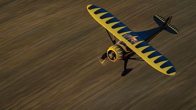
Aerial survey work is often described as “mowing the grass,” methodically flying a grid to capture images at a constant altitude and airspeed. It requires skill and a steady hand to fly with precision, though the pictures are often not particularly exciting. Between those missions, a sharp-eyed pilot-photographer can find magic.

Steve Benner spent six years crisscrossing the continent on survey jobs, and kept his camera handy between “mowing” sessions. Benner shared some of his work with AOPA, ever modest about what he was able to achieve with aircraft and camera.

"All of the images are grab-shots of things that I was fortunate to see along the way,” Benner wrote in an email. “I guess it proves that if shoot enough, you eventually luck into some good ones.”

That brings to mind a famous quote attributed to various sources: “Luck is what happens when preparation meets opportunity.”

Jim Moore

Jim Moore

Managing Editor-Digital Media
Digital Media Managing Editor Jim Moore joined AOPA in 2011 and is an instrument-rated private pilot, as well as a certificated remote pilot, who enjoys competition aerobatics and flying drones.
Topics: Travel, People

Related Articles