Photography by Mike Fizer
New Zealand’s steep-sided Southern Alps rise majestically from the deep blue Tasman Sea to form a jagged line of snow-covered peaks that stretch almost the entire length of the country’s South Island.
Craggy and ice capped, even during summer, the long and narrow range of sawtooth rock faces comes into razor-sharp focus with an assist from the absolute clarity of the surrounding air. Visibility on this late-summer dawn exceeds 150 miles, a common occurrence on a windy island far from any continental land mass, or the haze and congestion that can come with it.
New Zealand by the numbers
- Population: 4.4 million people (30 million-plus sheep)
- GA pilots: 6,500
- GA aircraft: 2,500
- GA airports: 70
- GA flying clubs: 46
- Avgas: $11 a gallon
Our flight of two aircraft—a Cessna 182 Skylane and an Aviat A–1C Husky—is scouting out the fjords on the southwestern tip of the country. And although we’ve crossed over tropical beaches, smoldering volcanos, the roiling Cook Strait, and the indescribably rugged and pristine west coast of the remote South Island during the 500 nautical miles we’ve covered on our journey from New Zealand’s North Island, the Southern Alps stand apart for their majesty and geological drama.
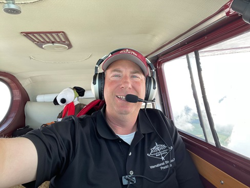
New Zealand pilots Matt McCaughan (pronounced McCorn) and Sam Bowering are leading in the Skylane with AOPA Senior Photographer Mike Fizer there to record the scenes. Jack Schulte, an American citizen and New Zealand resident, and I are following closely in Schulte’s Aviat A–1C Husky, the only airplane of its kind registered and flying in the country. McCaughan and his wife, Jo, founded Flyinn New Zealand (see page 55), a self-guided aerial tour business that caters to international pilot guests and their families, and McCaughan has logged thousands of flying hours over this peerless landscape.
Distances in New Zealand seem short by North American standards, and most single-engine airplanes can easily cover the 500-nm distance from the tropical North Island's Bay of Plenty to the fjords of the alpine South Island in a single day.
“That’s Mount Aspiring, known as the Matterhorn of the South for obvious reasons,” he says cheerfully over the aircraft radio as the ice-encrusted, windswept pinnacle comes into view. “Aspiring’s 9,951 feet high, so it’s not quite the tallest mountain in these alps. But just about everyone agrees it’s the most beautiful.”
The highest mountain in the chain is Mount Cook, a massive and solitary outcropping of three peaks that rise more than 12,300 feet from the ice-blue Tasman coast. It is about 70 nm north of us.
We follow the meandering path of the Matukituki River as it rises steadily from an elevation of 1,300 feet at Lake Wanaka to 5,000 feet at the Matukituki Saddle about 15 miles west. Like many other rivers in this part of the country, the Matukituki is known for trophy trout. The braided river shifts along the gravelly floor of a tightly sculpted glacial valley.
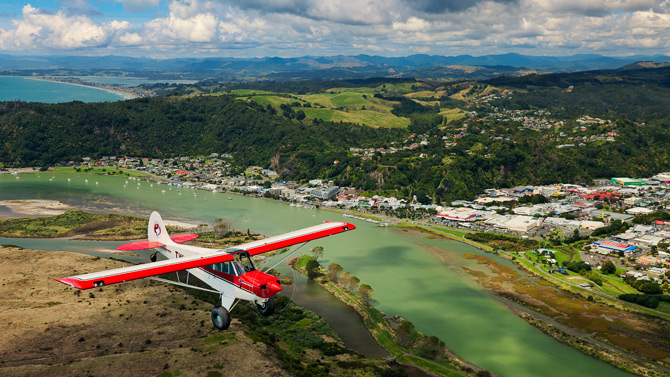
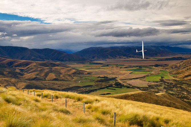
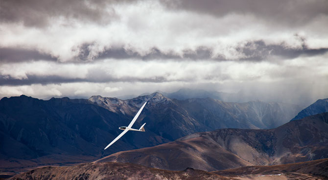
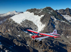 An Aviat A–1C Husky is perfectly suited to New Zealand's Southern Alps, a rugged mountain chain that stretches the entire length of the country's South Island.
The Skylane is climbing at full power and hugging the south-facing slope of the nearby mountains, and we do the same in the Husky in an effort to catch the rising air from the reflected morning sun, as well as the mechanical lift from a steady, dry southerly breeze.
It works, as our climb rates exceed 2,000 fpm at times—but it’s becoming a rough ride as powerful air currents, disrupted by rough interplay with Fog Peak and other serrated mountains, toss us at their whim.
“She’ll be right in just a few more minutes,” McCaughan assures us in a typically understated Kiwi way. “Just a wee bit of disturbed air to contend with.”
We turn north at 7,500 feet and overfly the Bonar Glacier, a brilliant white sheet of fractured ice and snow at the southern edge of Mount Aspiring. The surface temperature at sea level was 65 degrees Fahrenheit, and it’s in the low 40s here, but the landscape has changed in less than 30 miles from verdant farmland and rolling hills with herds of woolly Merino sheep to a seemingly endless series of sparse, barren, and forlorn alpine peaks.
From our altitude, Mount Aspiring’s sharp spire reaches high above and stabs vertically into the heavens—a sight that is both jaw-dropping and slightly vertigo inducing. Undulating ridgelines and massive mountains with tops far above us obscure the actual horizon, and my own perception of level flight diverges at times from the correct one shown on the Husky’s attitude indicator.
We turn southwest and cross the Dart Glacier, then follow the Dart River downstream. The mountains here all seem to possess their own distinctive characters: tall, rocky, and imposing; squat, rounded, and golden; wrinkled, icy, and ancient. They also will seem familiar to fans of the Lord of the Rings movie trilogy that was filmed here and at other New Zealand locations.
Kiwi aviation parlance
Circuit—pattern
Vacating—departing
Tracking—en route
Back track—back taxi
Apron—ramp
Sou’east—southeast (same for nor’west)
Non-aviation Kiwi terms
She’ll be right, mate—Don’t worry, pal
Give it a go—try
Gone to custard—gone awry
Roit—right
Tea—dinner
Drizzle—downpour
Toilet—bathroom
Togs—swimsuit
Buggered, stuffed, or rooted—impolite synonyms for all fouled up
The fictional Mount Doom where the Frodo Baggins character goes to dispose of the first ring is actually Mount Ruapehu, and Hobbiton was really the rolling hills of Matamata. When viewed in theaters, the epic peaks seem like a fictional, or at least a vastly enhanced, Hollywood invention—but in person, the actual mountains are more breathtaking than they could ever be on film.
Looking north and west, the mountains drop away rapidly to the nearly uninhabited coastline just 20 miles away. From our altitude, it appears we could almost glide to the rocky beaches and endless surf. Milford Sound, a stunning fjord with an airport at its apex, is almost within view, and we’ll go there later in the day when the sun is overhead to light the narrow canyons leading there.
We turn northeast and follow the Dart River, upstream this time, across the Cascade Saddle (elevation 5,000 feet), then descend toward Lake Wanaka. There, we follow a river known as the Dingle Burn and land on a farm field in the shadow of Mount St. Mary, a solitary and serene 7,667-foot peak.
Our aerial excursion through the Southern Alps lasts just under two hours, but the impressions are indelible. These mountains, at the intersection of incalculably potent natural forces, are a meeting place of persistent winds, massive earthquakes and volcanic eruptions, glaciers, blizzards, avalanches, plunging waterfalls, and torrential rains.
On a day like this, however, the alps appear tranquil. And seeing them from the intimate perch of a responsive, tube-and-fabric airplane that rides the air currents like a hawk is pure magic.
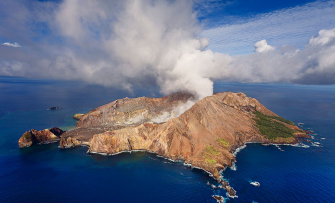
White Island was named by Capt. James Cook, the first European visitor to New Zealand, for the steamy volcanic clouds that emanate from it almost constantly.
Flyinn New Zealand
The real deal 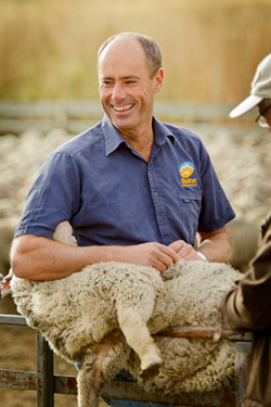
When Matt and Jo McCaughan decided to host overseas pilots at a sheep station that had been in their family for four generations, they did so for economy and convenience.
They already had a grass runway, extra cottages for guests, and a shed to protect airplanes from winds and weather. And they hoped visitors would enjoy an authentic glimpse of farm life on a working sheep station in the heart of Merino country.
The McCaughans and their 5,200-acre spread, Flyinn New Zealand, have become a fascination for guests, and one of the main draws for nonpilot spouses who make the long trek to Geordie Hill Station from Europe, Asia, or the United States.
“We didn’t think a sheep station would be all that interesting to our guests, many of whom are international travelers who have been to all sorts of exotic places,” said McCaughan, a rancher who raises both sheep and cattle at the family property about 12 miles northeast of Wanaka, a South Island vacation destination. “We’ve been surprised at how much our visitors are interested in all aspects of running a sheep station.”
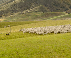
McCaughan, his farm managers, and a half-dozen dogs keep close track of about 8,500 Merino sheep at Geordie Hill, a hardy variety whose wool is prized as among the world’s finest. Watching the dogs work on voice or whistled commands is astonishing.
 McCaughan operates several 180-horsepower Cessna 172s and says they’re ideal for pilot visitors, almost all of whom have flown similar airplanes at some stage in their past. They also have the power to climb in the sometimes-high density altitudes of the Southern Alps.
“The 172s are easy to fly, simple to maintain, and reliable,” he said. “We take them all over the country without any hesitation whatsoever.”
Jo McCaughan is a pilot, but instead of leading aerial tours, she specializes in preparing sumptuous cuisine, much of it made from local produce, and keeping their website current.
The McCaughans typically visit the United States once a year to attend EAA AirVenture in Oshkosh, where they meet with former guests and invite new ones. —DH
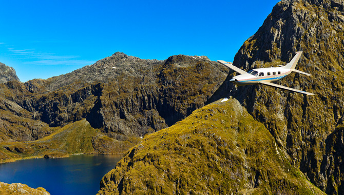
Canyon-wall challenge
Threading through the fjords in a Malibu
The crystal-clear water that fills the center of a mountain volcano at Lake Quill turns into a shimmering white torrent known as Sutherland Falls as it spills over the rocky edge and rains down the sheer cliffs into the Arthur River nearly 2,000 feet below.
This mesmerizing natural wonder marks the beginning of the south approach to Milford Sound Airport, a 2,600-foot strip in the fjords of southwestern New Zealand surrounded by towering rock walls that extend thousands of feet above on three sides.
The only approaches are through a canyon from the Tasman Sea, or an even thinner gap formed by the Arthur River. The canyons leave enough space for two airplanes to pass in opposite directions, but the claustrophobic feeling of flying here is made more acute by the towering height of the rock walls.
I’m flying this portion of our trek with New Zealand pilot Ian Andrews in his Piper Malibu, and the feisty Kiwi rejects any suggestion that his airplane is too big or too fast to make the plunging approach and landing at Milford.
“Don’t underestimate the bloody Malibu,” Andrews, an instrument-rated private pilot, says. “It’ll handle Milford without breaking a sweat.”
It’s sunny and warm, a rarity in New Zealand’s fjordland where steady trade winds from the Tasman Sea regularly create low clouds, rain, and fog throughout the year. We fly by Sutherland Falls and then make a plunging left turn into the canyon, lowering the Malibu’s landing gear and flaps to hasten our descent. Andrews broadcasts our position, and a flight service specialist on the ground at Milford keeps us informed of traffic and wind conditions. One of New Zealand’s most challenging airports is also among its busiest as tour companies, mostly from nearby Queenstown, send a steady stream of passengers to Milford and ships that ply the sparkling sounds.
At a distance of five miles, we are 1,500 feet above the churning water, and the Malibu’s long, high-aspect-ratio wings appear uncomfortably close to the rock walls. The tremendous depth of the canyon keeps us in shade, even during the middle of a sunny afternoon. A 10-knot sea breeze pushes up the fjord, and it creates a steady light chop. The mouth of the river meets the fjord near the approach end of Runway 29, but there’s just not enough room to enter the pattern on base. We level off at 1,000 feet and make a hard right turn. We’re on a left downwind for Runway 29 and headed into a box canyon with walls that reach vertically more than 3,000 feet. Andrews hugs the canyon wall with the Malibu’s right wing tip and waits as long as possible before turning left base, then final. With full flaps, gear down, and prelanding checklist complete, he aligns the airplane with the runway and levels the wings at 500 feet agl. Airspeed is 85 knots—just where it should be for landing.
“From here on, this is just a normal landing,” he says, then touches down on the numbers and brakes moderately. The Malibu comes to a stop slightly beyond midfield, and turns onto the ramp shared by 13 other airplanes—including Islanders, Caravans, and Cessna 206s flown by professional tour operators. There are a few Cessna 172s, a Piper Arrow, and a Piper Cub whose owners took full advantage of an ideal day to visit one of the most scenic places on Earth by air.
We tour the area on foot, then clamber back into the airplane and launch downhill and into the wind. In accordance with local practice, we fly close to the northern wall of the sound (which pilots call “Mount Lift” for its rising air) as we depart. Kiwis drive on the “wrong” side of the road but they like to pass left-to-left in airplanes, just like U.S. pilots do. We fly straight out the mouth of the sound at about 1,000 feet, and then turn right to follow the coastline northwest.
Over Omarama
Soaring in the ‘place of light’
The electronic variometer in the Duo Discus high-performance glider starts singing its happy, high-pitched song a few moments after we release the tow rope from the Piper Pawnee.
A strong northwest wind creates mechanical lift over the ridges, and from our release point at 2,200 feet agl, we are headed up at a steady 400 fpm. High above, the beginning of lenticular clouds shows the presence of powerful winds aloft, and a mountain wave appears to be forming that pilots here commonly ride into the flight levels.
“So many glider world records have been set here that we’ve entirely lost count,” said Gavin Wills, founder of GlideOmarama, a New Zealand firm that teaches new glider pilots, takes visitors on aerial glider tours, and hosts some of the world’s most accomplished glider pilots at this soaring Mecca where Wills’ uncle pioneered wave soaring in the 1950s and 1960s. “Omarama is a Maori word that means ‘place of light,’ and the visibility here gives new meaning to the word unlimited.”
The grass airstrip at Omarama, about 60 miles east of Mount Cook on New Zealand’s South Island, has been a launching pad for epic glider flights that sometimes cover the entire South Island in a day. Trips of more than 600 miles are common, and a recent world record topped 2,500 kilometers (1,522 miles).
The reason for the world-class gliding conditions has to do with the mountains and wind. The jagged mountain range of towering peaks on the island’s west coast meets powerful and persistent trade winds blowing in from the west in these latitudes that sailors long ago dubbed the “Roaring 40s.” The collision of these two natural forces creates a launching ramp for glider pilots that they sometimes can ride into the stratosphere.
When conditions are right, other-worldly lens-shaped lenticular clouds—sometimes stacked atop one another—form over the Omarama valley. They signal the presence of mountain waves that lift gliders above 20,000 feet with regularity, and there’s potential to go far higher.
Adventurer Steve Fossett was a regular here for several years before he was killed in a 2007 aviation accident in California. Although he didn’t succeed in setting an absolute altitude world record for gliders at Omarama, he did reach 38,000 feet there and set a series of glider speed records over a variety of distances. (Fossett set the current glider altitude record of 50,699 feet in Argentina.)
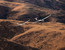 Mountains, sunlight, and strong winds are some of the elements that come together at Omarama on New Zealand's South Island to create ideal soaring conditions that attract glider pilots from around the world. A fleet of Duo Discus gliders takes visitors on flights that reach altitudes of 25,000 feet.
In an effort to attract more young people to flying, GlideOmarama has founded a youth soaring program, and participants as young as 13 have soloed here. Unlike the United States, where the minimum age for soloing a glider is 14, New Zealand has no lower limit.
“I’m sure it was an oversight and the regulators simply forgot to put an age limit on glider flying here,” Wills said. “That’s just fine with us.”
Our release point is on the southwest side of a craggy and unremarkable peak glider pilots here call “Mount Horrible” (so named for an accident that banged up Wills’ father but didn’t dampen his enthusiasm for the sport). We climb steadily, traversing the ridges. When the Ewe Range becomes visible to the southeast, we fly to the steep, snow-topped hills and are rewarded with a quick surge in altitude that raises the German-designed Discus all the way to the cumulus cloud bases at about 7,500 feet.
A mountain wave is forming above the clouds, and the wispy tops curl to the east, showing the direction of the freshening winds. We try several times to top the clouds, but the wave somehow passes us by, and turbulent rotors flex the Discus’ 21-meter wings roughly. We listen for the variometer to chirp and the choppy “rotor dance” to smooth out in the wave. But instead the variometer moans, signaling an altitude loss.
Mountain waves on the lee side of tall ranges were discovered in 1933 by a pair of German glider pioneers. The U.S. Air Force studied the phenomenon in detail in the 1950s and glider pilots began a series of extreme high-altitude flights that began over the Sierra Nevada range in California and ended hundreds of miles downwind to the east.
New Zealand’s wave-riding pilots don’t have the option of flying long distances downwind because doing so would push them far out to sea. So they were among the first to fly perpendicular to the wave, much as a surfer riding along a beach, in an ongoing series of long-distance, high-altitude, high-speed flights.
We’ve been airborne for nearly two hours and, despite my semi-reclined seating position, the parachute I’m wearing is starting to make me squirm. The mountain wave, for today at least, has eluded us. The Discus’ 44:1 glide ratio makes returning to the Omarama airport quick and easy. The east/west turf runway is clearly identifiable from more than 20 miles away, and I let the nose drop and fly straight there at a relatively speedy 100 knots.
Entering the right downwind for Runway 27, we set the glider down on a broad grass strip among a half-dozen others preparing to launch. A steady rain is falling in the mountain valleys about 20 miles west, but Omarama, as usual, remains dry. It’s in a rain shadow that gets very little precipitation while the mountains create rain forests on the coast 50 miles away.
The approaching autumn season is the end of the busy part of the year for gliding at Omarama, and many of the guests and instructors are preparing to leave. They come from Australia, Canada, France, Germany, Russia, the United Kingdom, and United States. Some of the instructors alternate gliding seasons in the northern and southern hemispheres, an endless summer of soaring.
But wherever they go for work, and wherever they call home, they usually seek to return to this scenic valley and the community of kindred spirits drawn here.
“We have our own miniclimate here at Omarama that makes it a paradise for flying gliders,” Wills said. “People come here from all over the world, and they have for years, because the flying opportunities here are unique. It’s unlike any other place on the planet.”
Email the author at [email protected].
Both familiar and exotic: The regs look similar but the terrain sure doesn’t
Flying in New Zealand feels both familiar and exotic for U.S. pilots. Most of the regulations are little changed from those in the United States; the airplanes themselves are identical (lots of Cessnas and Pipers), airport markings are mostly alike, and voices on the radio speak English.
It’s much different, however, in the dramatic terrain variations, rapidly changing island weather, reliance on VFR flying, unpronounceable places, and altered procedures.
One of the first steps for visiting U.S. pilots is a short-term validation that allows us to use our certificates to fly New Zealand-registered airplanes for up to six months. The process involves flying with a New Zealand CFI who administers something that closely resembles a biennial flight review.
I flew with Peter Rutledge of East Bay Aviation at the Whakatane Airport on the North Island’s aptly named Bay of Plenty in a Cessna 172N. The hour-long flight included steep turns, stalls, emergency procedures, and other familiar items along with a few new ones. Compass turns were made more interesting by the fact that the little orb moves and dips in the opposite direction to what we’re accustomed to in the Northern Hemisphere, and traffic patterns at nontowered airports are done in the English fashion—circle overhead at 1,500 feet agl, then descend over the “nontraffic” side and enter the downwind at 1,000 feet agl.
The Kiwis also prepare for scud running, and want you to show that you can fly at 600 feet agl with a notch of flaps just in case you have to follow a road, river, or power lines in low visibility. (They also require a hatchet and fire extinguisher in each airplane.)
And even though few visiting GA pilots will choose to fly IFR in New Zealand because the regulatory requirements are relatively onerous, make sure to hone your NDB skills before coming. NDB approaches are plentiful, GPS approaches are up and running (but WAAS isn’t), and in-cockpit weather reports such as XM Satellite Weather aren’t available.
New Zealand VFR sectional charts take some getting used to, and symbols such as the red circles (and there are many) which represent active volcanos accentuate the fact that this land is so very different. One welcome aspect to VFR flying here is the total lack of TFRs.
U.S. pilots seeking short-term validations must bring their pilot certificate, medical, and pilot logbook. The logbook is important because it shows both currency and the types of airplanes flown, and every “type”—such as a Cessna 172, 182, and 206, for example—requires a separate “type rating” here.
Matt McCaughan of Flyinn New Zealand offers short-term validations but strongly recommends visiting pilots fly with staff instructors who act as guides and coordinate their customers’ journeys from end to end.
“Even for pilots who are experienced and current, flying here can be extremely challenging,” he said. “We’ve got the mountains, so we offer specific mountain-flying courses. But the terrain here changes rapidly along with the weather, and our instructors are familiar with the patterns; they know the alternate airfields; and they keep people safe and help them enjoy the whole experience.
“It may sound surprising, but veteran pilots with many thousands of hours who come here are usually more open to flying with local instructors than relatively low-time pilots,” he said. “The experienced pilots know that they always have more to learn.” —DH

Dave Hirschman
Related Articles